
|
Only have a minute? Listen instead
Getting your Trinity Audio player ready...
|
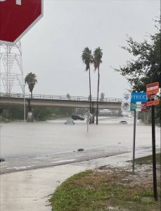
The copious rain that pounded sections of the Rio Grande Valley ahead of the Thursday cold front was great for lawns and other green things, but not enough to improve low reservoir levels up the river.
So says Barry Goldsmith, warning coordination meteorologist with the National Weather Service Brownsville-RGV station, who called Thursday’s precipitation a “citywide event” for Brownsville residents that dumped up to 4 inches in some spots. Way up the river, rainfall estimates based on radar were in the 1.5- to 3-inch range, most of it along the Rio Grande between Eagle Pass and Laredo, he said.
Rain in that area flows into Falcon reservoir, though this time around it wasn’t much more than a drop in the bucket, possibly enough to temporarily arrest falling water levels, Goldsmith said.
“If you go farther north, there was some rain into Mexico that may have hit a little bit of the Rio Conchos, which kind of heads up toward Amistad (Reservoir), but around Amistad itself the rain was fairly nonexistent,” he said.
Amistad, about 330 miles north-northwest of Brownsville as the crow flies, is huge and needs a lot of rain to fill it up, he noted. Falcon is much closer, roughly 120 miles northwest of Brownsville.
Without a lot more rain, the U.S. share of conservation water capacity from both reservoirs is likely to remain at or below the 30-year low, according to state data, Goldsmith said
“There’s a long, long way to go,” he said.
According to last measurement, taken Oct. 5 before the rains moved in, showed the combined share had dropped to 21.4% from 22.7% by the previous measure, he said.
“That number is, I want to say, at or a smidge higher than the low values that we saw last August,” Goldsmith said.
There is rain in the forecast for next week, which may come to pass depending on what Tropical Storm Lidia (expected to reach hurricane strength Friday), does in the Eastern Pacific, he said. An upper level low-pressure system lurking off Baja and Southern California will cause the storm to boomerang back toward the Mexican coast, which may send tropical moisture into South Texas, or not.
“The question at that point is how strong will it be when it reaches Mexico,” Goldsmith said. “The forecast right now is for it to weaken back to a tropical storm, I think affected by some wind shear. And then where it does it move in, what’s left of it when it comes into Mexico and how far north does it come? There’s still an outside chance for more helpful rains, but we’ll know much more on this by next Monday.
“The key here is can it gain enough latitude to become that feed of effective tropical moisture, to get into both Amistad and Falcon, or at least Falcon?”
It’ll be a race between the potential flow of tropical moisture and an even stronger low-level cold front on its way to the Valley delivering drier October air — and more delicious weather, he said.
“It doesn’t meant the front itself will be dry,” Goldsmith said. “We’ll see some more rain along that next front, but behind it we’re talking low humidity. Nighttime temperatures would be in the 50s, maybe even upper 40s across the ranch lands. Daytime temperatures could be only in the 70s to around 80.”
If the front gets here first it’s guaranteed to kill off any eastern tropical “re-curve” from Lidia, he said. Depending on what happens with El Nino in the latter third of autumn into winter, it’s possible the extremely warm waters of the Eastern Pacific, aided by the extremely warm waters of the southwestern Gulf of Mexico and Bay of Campeche could help the reservoirs, Goldsmith said.
“It could happen,” he said. “Again, there’s a lot of uncertainty on that. It’s pretty far away. You’re talking two months from now. We just can’t crystal ball it very well. If we continue to see these low-pressure areas off of Baja, off of let’s say Cabo (San Lucas), west of Southern California, being more dominant than a ridge of high pressure, that would be helpful.”
That scenario would allow deep tropical moisture from the eastern tropical Pacific — off the coast of Central America and extreme southern Mexico — to enter other parts of Mexico and “maybe squeeze into parts of South Texas … all the way over to Florida,” Goldsmith said.
“That could be a boost for the reservoirs, but that’s a real unknown right now,” he said. “We’ve just got to wait and see how this pattern evolves as you move deeper into fall.”


