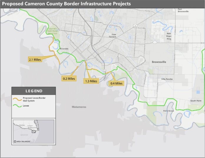
The federal government confirmed Wednesday that it plans to build 19 miles of new border wall in Cameron County.
In advertisements published in The Brownsville Herald, The Valley Morning Star and The Monitor, U.S. Customs and Border Protection announced it is soliciting public comments on the location and potential impacts of border barrier projects, including 19 miles of levee/border wall in Cameron County, 24 miles of levee wall system in Hidalgo County and 52 miles of border wall system in Starr County for a total of 95 miles of new border structures in the Rio Grande Valley.
In Cameron County, U.S. Customs and Border Protection is targeting 11 areas from south of Santa Maria at the Hidalgo/Cameron County line down to Brownsville, where CBP wants to build four miles of levee wall in areas just south of the city and another 7.1 miles to the west of the city.
South of Los Indios, the government intends to build 1.2 miles of new border wall. Just to the southeast of Bluetown, CBP has planned 3.8 miles of border wall with another 2.7 miles south of Santa Maria, at the county line.
This is the first public disclosure CBP has made to Cameron County residents about its plans to build new border wall in a region that has had the structure for a decade.
Unlike in Hidalgo County, where CBP is planning 25 miles of levee wall fencing, and in Starr County, where the agency wants to build eight miles, the only border wall work here has been to install up to 11 gates in gaps in border fencing.
However, over the past two months, the government has filed four lawsuits in federal court in Brownsville against property owners in Cameron County seeking right-of-entry.
The newspaper also obtained an email sent to residents of the River Bend Resort & Golf Club in west Brownsville outlining CBP’s plans to build border wall in that area in 2020.
The River Bend Resort & Golf Club is south of Military Highway by Veterans Early College High School and the West Rail Bridge to Mexico.
It sits near 34.015 acres owned by Antonio Manual Diaz, Diana Nori Diaz and Thomas Edward Diaz, the heirs of Maria Hilaria Cavazos Diaz, who the government sued in late June, seeking entry to the property.
That land is between the River Bend Resort & Golf Club and a small neighborhood in San Pedro where the government sued two families who have homes near the river levee.
The government has also targeted an agricultural property approximately one mile northwest of the Silas Ray Power Station, which is located off of Power Plant Drive on the western edge of Brownsville.
That land condemnation lawsuit is against Robert R. Mathers and Edward Mathers Farms, who complained in court documents that the government has already placed equipment on his property without his permission and without compensating him.
CBP budgeting documents indicate that it is using $1.6 billion in funding approved by Congress last March to fund 65 miles of new border wall system in Southern Texas.
That’s 30 fewer miles than CBP is proposing in a letter dated June 27 seeking input on potential impacts of new border wall in Cameron, Hidalgo and Starr counties. That letter states that CBP is proposing 95 new miles of border wall in the Rio Grande Valley.
Comments will be accepted until Aug. 26 and can be submitted through www.regulations.gov, by searching USCBP-2019-0018 or via mail to U.S. Customs and Border Protection, U.S. Border Patrol Headquarters, 1300 Pennsylvania Ave., 6.5E Mail Stop 1039, Washington, DC 20229-1100.


