

HARLINGEN — One year ago, a broad tropical wave swept out of the western Caribbean and headed straight for the Rio Grande Valley.
The system never made it to tropical storm level, let alone hurricane status.
But the Great June Flood of the Rio Grande Valley certainly left its mark, dropping rain measurable in double-digit inches over four dreary days, leaving behind at least $250 million in damages.
“(It was) potentially much more rainfall from an organized tropical cyclone that decides to sit and spin over the region for a few days — perhaps worse than Beulah — but in a region with five times the population and exponential infrastructure growth,” the National Weather Service in Brownsville reported in its post-event analysis.

Perhaps the most enduring impact the rain and flooding left in the Valley’s cities and towns, in its colonias and on its farms and ranches, is an enduring worry about next time.
Arroyo’s capacity?
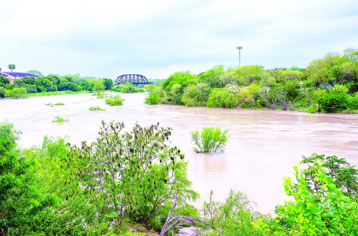
The City of Harlingen was one of the wettest spots during the deluge in the Valley, recording 16.85 inches of rainfall over four days beginning June 18.
City officials also believe residents were lucky, and flood damage was minimized due to rain falling in bursts, often with gaps of two to three hours with no precipitation. They say this pattern allowed most of the city’s drains and flood-mitigation system to siphon off the water into the Arroyo Colorado.
Keeping the Arroyo Colorado clear of undergrowth and siltation which can reduce water flow is the responsibility of the International Boundary and Water Commission, the joint United States-Mexico agency formed in 1889 to determine the international boundary given the meanderings of the Rio Grande.
The IBWC also has authority over protecting the region from flooding.
The Arroyo Colorado can only push water at 45 percent of the design discharge capacity of 21,000 cubic feet per second. But IBWC officials have said that after their planned improvements of dredging the shallow arroyo and clearing vegetation, the arroyo should be able to reach that 21,000 cfs flow rate.
Harlingen officials have their doubts.
IBWC study
The top flow of the Arroyo Colorado at Harlingen during last year’s rain event was 5,069 cfs on June 21, and the river’s flood gauge stood at 23.98 feet.
To get a sense of proportion, the flow rate on the arroyo during Hurricane Alex in 2010 was 5,500 cfs and the flood gauge reached 24.22 feet. There was significant flood damage around the Valley during the fallout from Alex’s landfall.
In Harlingen, officials such as Assistant City Manager Carlos Sanchez, himself an engineer, hope a new study of the arroyo’s capacity promised by IBWC will provide a more accurate assessment of the arroyo’s flow rate during a flood event.
“That’s part of the analysis, the study, that by doing an updated hydraulic study is that it’s going to identify the true capacity of the arroyo,” Sanchez said. “And at the same time, it will identify the spec that, yes, it cannot carry the 21,000 cfs.”
Sanchez feels flow-rate knowledge, in this case, will be power when it comes to responding to future flooding events.
“So if we’re short, say I don’t know, 10,000 cfs, how do we compensate, how do we mitigate those 10,000 cfs?” Sanchez asked. “The study will helps us analyze and help IBWC to identify that OK, we’re not able to flow 21,000 so we need to detain 10,000 upstream by either building retention ponds, building weirs or some sort of capital improvement structure upstream, so that the water is either detained or diverted.
“And that’s what I’m talking about — the balance,” he added. “In my mind, if we can divert some of the high peak flows to the North Floodway before we send water down the arroyo, then that gives the cities the opportunity to drain or continue draining into the arroyo.”
The North Floodway is a diversionary path for floodwaters away from the Arroyo Colorado, which can be opened or closed depending on conditions.
What Sanchez envisions is using the North Floodway to give cities downstream time for floodwaters to drain before more water is sent down the Arroyo Colorado itself, hence his reference to a balance between what the IBWC can do and what cities can do.
“By the time the IBWC released their water into the arroyo, the water from the cities have kind of already flowed out and gone downstream,” he said. “That’s part of the storm water or water management features, I guess, that’s going to result from a detailed hydraulic study that we can do that.”
Lobbying for changes
The detailed hydraulic study of the Arroyo Colorado to be performed by the IBWC initially targeted the arroyo from the bridge at U.S. Business 77 near Ed Carey Drive down to the Port of Harlingen.
But Harlingen officials as well as other municipal leaders lobbied IBWC Commissioner Jayne Harkins — city officials have met with her several times, and say she has been receptive to their concerns — for the study area to be expanded farther upstream in order to better predict the arroyo flow rate.
“So that’s what we’ve been pushing for really, because that’s going to give us an analysis, a hydraulic study, for the area that’s primarily the populated area, from Mercedes to La Feria to Harlingen to San Benito down to the port,” Sanchez said.
The IBWC’s Harkins agreed, and the study area has been expanded upstream. IBWC also is moving forward with plans to dredge the shallow arroyo as well as to cut back vegetation which hinders the rate at which floodwaters can move.
“IBWC is currently working on the hydraulic model and environmental documentation that is required to secure the permits deemed necessary before IBWC can start removing the sediment within the limits of the Arroyo Colorado,” said spokesperson Lori Kuczmanski. “Permits can take anywhere between six to nine months once we submit the request.”
In this together
Even though the hydraulic study of the arroyo has been delayed, Sanchez and other Harlingen officials still believe we are in better shape to withstand another major rain event precisely because of the concerns raised by what happened last June.
“I think we are in better shape in the sense that the conversation, the focus on the need for improvement, is there, it’s on the table and it’s being discussed, from an operational standpoint,” Sanchez said.
“The communications amongst communities here along the arroyo and in the area are also in a better condition,” he added. “I think internally from the city’s perspective we have also identified operational efficiencies … and will be more proactive in responding to the localized flooding where we either close roadways and detour traffic from entering a flooded area so that either they don’t sustain any damage or driving down the street doesn’t cause a wake that pushes water up onto private properties.”
The Rio Grande Valley is now three weeks into the summer hurricane season, which will last until Nov. 30
Here in the Valley, fallout from the Great June Flood of 2018 was a jarring reminder of the catastrophic damage a rain-swollen hurricane could cause in a region which is far more densely populated and developed than it was during Beulah or even Dolly.
As for a potential hurricane this summer, Sanchez has a plan there, too.
“I’m praying and lighting a candle about that,” he said.
Impact facts
More than 7,400 residences and businesses in Cameron and Willacy County suffered flood damage defined as minor to destructive by FEMA Standards.
At least 20,000 residences and businesses considered “affected” by the floods. This includes the 7,400 listed above.
More than 600 persons sought refuge in at least 10 shelters at the peak of the area-wide flooding.
Several thousand vehicles suffered varying degrees of flood damage.
Dozens to hundreds of roads, from neighborhood streets to major thoroughfares and frontage roads, closed during and after peak flooding.
More than 2,000 rescues from vehicles and homes were conducted.
21,000 meals served by the American Red Cross.
Public infrastructure damage of at least $50 million in Cameron and Willacy County alone.
Source: National Weather Service/Brownsville
What happened?
A broad tropical wave originating in the western Caribbean Sea moved across the Yucatan peninsula on June 15 and 16, 2018.
The slow-moving but persistent system approached the Texas coast on Sunday, June 17, before finally arriving on June 18.
As the center axis of the wave passed the longitude of the coastline, the gates opened to repeated surges of tropical moisture deep into the atmosphere with origins in the western Caribbean.
A series of upper-level disturbances interacted with this wave throughout its life cycle and helped to maintain a broad area of low pressure at all levels of the atmosphere for the period from June 18 to 22 across the Rio Grande Valley and the adjacent gulf waters.
Several surface-based boundaries and convergence along the coastline also aided the production of heavy rainfall. Individual convective “systems” spun in place at several points during the event.
Source: National Weather Service/Brownsville


