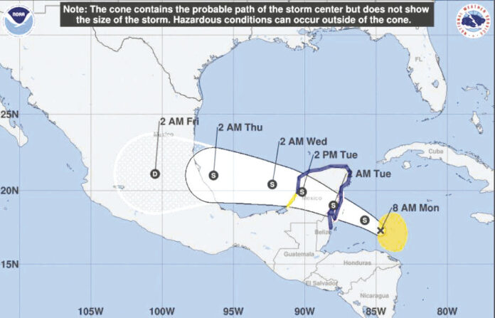
HARLINGEN — Tropical Storm Franklin should pass across the Yucatan Peninsula and re-invigorate itself in the Bay of Campeche as a hurricane.
So far, weather forecasters say, it looks like that’s where the storm will stay until it reaches land.
Yesterday afternoon, Franklin was moving to the west-northwest at 13 mph and the storm’s speed and direction are expected to continue pushing it toward Mexico, National Weather Service forecasters in Brownsville say.
“It could change, but at this point there’s a pretty good consensus among the models for landfall between Tampico and Veracruz,” meteorologist Matthew Brady said yesterday.
While it should remain well to the south of the border, Brady said the Rio Grande Valley is expected to feel the brush of the storm in the form of rain and lower temperatures.
By late Wednesday, forecasters in Brownsville say there will be a 30 percent chance of rain increasing to 50 percent on Thursday and then falling to 40 percent on Friday.
“Tropical storms often have a big deck of clouds that extend from the center of circulation, and those are the clouds that may push overhead into the Valley bringing some chances of rain,” Brady said.
Temperatures today will range from 95 along the coast to 105 up the Valley, and on Wednesday we can expect more of the same.
But as the outer bands of Franklin arrive, Thursday high temperatures should drop noticeably, from around 91 on the coast to 100 higher up the Valley. On Friday, the forecast is for high temperatures between 92 and 99 degrees in the Valley.
Franklin’s impact, at least as it stands now, will be indirect for most people.
“We will see higher seas across our coasts, and in gulf waters,” Brady said. “We’ll see higher surf on our beaches, and maybe even some beach erosion and minor coastal flooding as well.”


