
|
Only have a minute? Listen instead
Getting your Trinity Audio player ready...
|
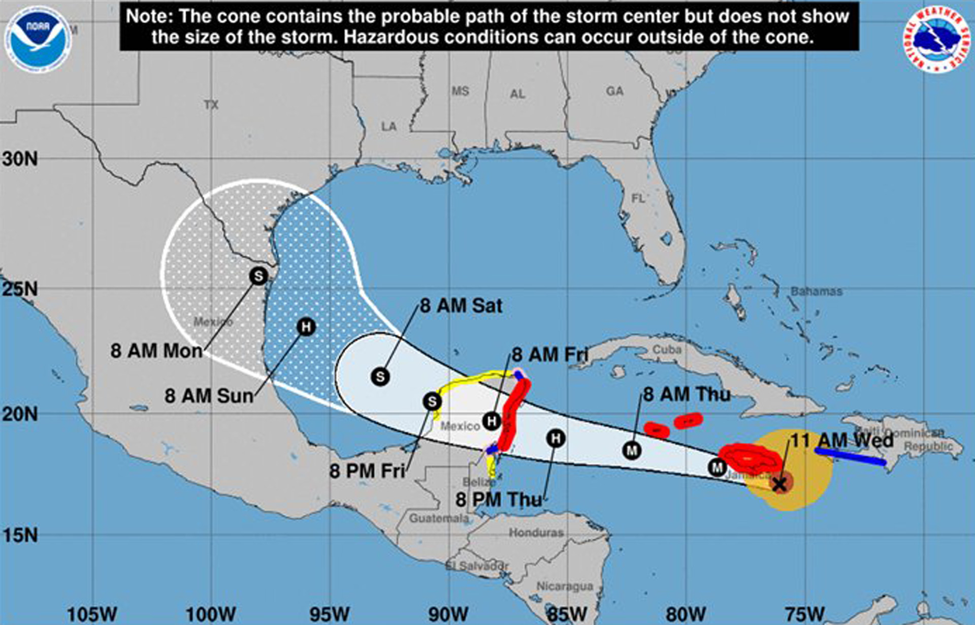
Meteorologists with the National Weather Service Brownsville-Rio Grande Valley station reported Wednesday that confidence is growing that Beryl, currently a Category 4 hurricane in the Caribbean, could have some impact on deep South Texas.
At the same time, much uncertainty remains about the eventual track and intensity of the storm, which is expected to cross the Yucatan Peninsula and enter the Bay of Campeche/southwestern Gulf of Mexico later this week, they said, adding that further details will be forthcoming over the next day as the forecast becomes clearer.
“Given the current track, deep South Texas could begin to see tropical storm-force winds as early as Saturday evening,” the meteorologists wrote in an email update. “The most likely arrival time of tropical storm-force winds for areas along the immediate coast is Sunday morning.”
Other hazards could materialize, though the exact timing is unknown, NWS said, though “confidence is increasing for coastal and marine hazards, including tidal run-up, rough surf and higher seas.”
Chances for heavy rainfall Sunday into early next week are increasing, though the Weather Prediction Center said southeastern portions of deep South Texas are looking at only a “slight risk of excessive rainfall,” according to NWS meteorologists.
This could lead to minor flooding and/or isolated instances of flashing flooding where heavier rain bands develop, they said. Beryl is encountering higher wind shear as it moves west/northwest, at about 18 mph as of Wednesday afternoon, which is expected to weaken the storm over the next few days, NWS said.
Meteorologists predict Beryl will further weaken as it moves over the Yucatan Peninsula on Friday.
“It is still unclear how much the storm will re-intensify upon entering the western Gulf of Mexico, though the current National Hurricane Center forecast has Beryl reaching hurricane strength before making landfall on the western Gulf Coast,” they said.
As of Wednesday afternoon Beryl was still a Category 4 and bearing down on the island of Jamaica, which was bracing itself for disaster.
NWS “strongly encouraged” deep South Texas residents to clear drainage ditches, canals, clean-outs and any other flood-prone areas where debris has accumulated. Preparedness plans should be reviewed and “stay or go” kits restocked.
“A (tropical) system is on the horizon,” meteorologists said. “Early preparedness now will ensure little to no panic later.”
Cameron County Judge Eddie Trevino Jr. on Wednesday ordered a voluntary evacuation of RVs and other high-profile vehicles from Andy Bowie Park and Isla Blanca Park on South Padre Island and Adolph Thomae Jr. Park in Arroyo City, based on the NWS forecast of Beryl’s path.
Campers who choose to stay are asked to secure chairs, tables, umbrellas and anything else that could blow, and consider retracting awnings and checking tie-downs.
Trevino encouraged campers to have backup generators on hand in case of power outages and monitor weather news for the latest updates.
“Having a plan of action in case the storm track changes or intensifies is also recommended,” he said, adding that the county will provide updates on any new developments regarding Beryl.
PREVIOUS COVERAGE:
With Valley in cone of uncertainty, NWS says don’t wait on storm preparation
Heating up: NWS says more tropical cyclones could impact South Texas


