

|
Only have a minute? Listen instead
Getting your Trinity Audio player ready...
|
The National Weather Service Brownsville-Rio Grande Valley station has issued its seasonal outlook for September through November, and it’s not good news.
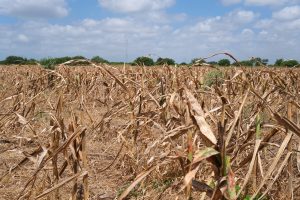
The “La Canicula” high-pressure ridge that set up over the region in early June is expected to continue through the first of September and possibly even beyond that, which NWS Warning Coordination Meteorologist Barry Goldsmith said would sharply suppress the easterly-southeasterly atmospheric flow that typically pumps tropical moisture across the region during September. That flow normally produces the highest rainfall averages of the calendar year, 4.5 to 6 inches total.
“A dry September, followed by a more typical dry October and November, would further exacerbate drought, water supply and wildfire-spread issues, especially given the high confidence in above average temperatures for the season,” he said.
At the same time, late September and beyond will bring fronts and “less hot” temperatures as the nights grow longer, Goldsmith said. But overall, the first two weeks of September likely will be an extension of the record/near record hot summer the Valley has been enduring, he said.
“The second half of September is leaning toward more heat, but a bit more uncertain is whether the deep tropical moisture arrives during the climatological peak of ‘wetness,’ which is roughly September 5-25,” Goldsmith said.
The bottom line is that isolated to scattered sea-breeze thunderstorms won’t make up the region’s monthly rainfall deficit, he said. Meanwhile, remnants of La Canicula into October and later “would lock in drier and warmer than average for the season as a whole,” Goldsmith said.
The currently evolving situation in the upper levels of the atmosphere suggest dry fronts in October into early November, though past that “uncertainty creeps in” thanks to correlations between what’s expected to be a moderate to strong El Nino in late autumn through winter precipitation, he said.
“El Nino is here and getting stronger,” Goldsmith said. “Summer onsets of such El Ninos can produce the hot and dry conditions we’ve been experiencing, continuing deep into autumn, which is one of the reasons we’re confident in this forecast.”
By late November and especially into winter, however, El Nino can “flip the pattern” by encouraging development of a powerful tropical jet stream from a warm, eastern tropical Pacific across Mexico, the Gulf of Mexico and the northern Caribbean as well as the U.S. Deep South, he said. If and when the jet stream connects with mid-latitude systems more common from late autumn through early spring, it could produce a lot of rain, Goldsmith said.
Let’s hope so. Otherwise it’s worsening drought, continuously falling reservoir levels, water-usage restrictions and Valley agriculture taking a hit.
As for whether Tropical Storm Harold was it for the 2023 Atlantic hurricane season as far as the Valley is concerned, it’s too soon to tell, Goldsmith said.
“We only need to recall 1967’s Beulah, which began as a Cabo Verde (Africa) storm around Labor Day and made it all the way to the Valley by September 20,” he said. “The trend through and past the peak of the season, Sept. 5-20, favors activity over the open Atlantic versus the Caribbean-Gulf region. That said, it still only takes one to change everything, and we need to be vigilant until early October.”


