
|
Only have a minute? Listen instead
Getting your Trinity Audio player ready...
|
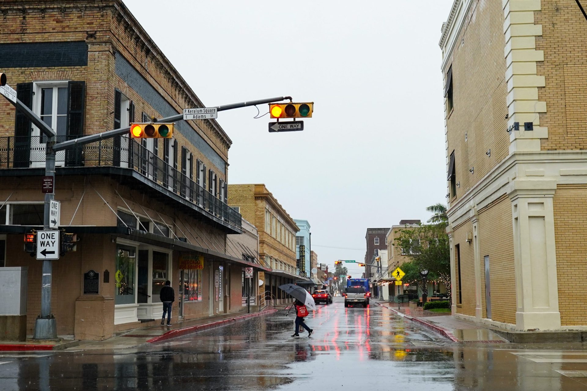
The persistent round of heavy thunderstorms shaking the Rio Grande Valley over the past many weeks, causing one death and several injuries when a tornado struck Laguna Heights on May 13, is unusual and has made for a cooler-than-normal spring.
Enjoy it while it lasts, which won’t be much longer, according to Barry Goldsmith, warning coordination meteorologist with the National Weather Service Brownsville-Rio Grande Valley station.
He said the seed for the Valley’s busy spring weather pattern was planted as early as winter, with a continuous westerly flow of jet-stream energy moving across the central and southern United States “at a pretty good clip.” Add to that remnants of low-pressure troughs moving from the Pacific Ocean into California, Nevada and Arizona, causing record weather events including a freak snowstorm in Southern California, Goldsmith said. Troughs don’t sit still, though, and eventually headed east, bringing their weather energy with them, he said.
Goldsmith noted that during winter there’s usually enough dry westerly flow coming off Mexico’s Sierra Cadre mountains to keep the Valley mostly rain-free despite any eastern-flowing energy, and that the Valley and ranch lands to the north indeed experienced severe to extreme drought last winter. Part of the reason it tends not to rain in winter is the atmosphere is too stable, he said.
But fast forward to April and May, when the sun is higher and the atmosphere, the eastern tropical Pacific and the Bay of Campeche in the southwestern Gulf of Mexico are warmer, and it’s a different story. Warmer temperatures mean more available humidity and heat, a combination that produces “latent heat condensation,” which creates energy that can push up into taller clouds and ultimately become rainmakers, Goldsmith said.
And then suddenly it’s moist instead of dry air rushing off the Sierra Madre and producing initial thunderstorm development along the mountain slopes and peaks, he said.
“Then they get pushed by disturbances in the atmosphere in that westerly flow — some of the same disturbances that we had in winter but now it’s spring,” Goldsmith said. “That energizes the atmosphere further to create the lift need to grow those storms into taller ones and eventually organize them into squall lines or clusters, and they get moved from west to east or northwest to southeast. They start up, say, between Del Rio and Laredo or west of there.”
Even when the energy waves are moving from west to east or southwest to northeast, the “vector movement” of the developing storms is at a right angle, which carries them right over deep South Texas and the Valley, he said.
“If there’s enough of those impulses in the atmosphere that are aiding the development of these storms on the slopes of the Sierra Madre, then they will come unencumbered right on across the Valley, and we’ve seen that several times beginning on April 21 with some of those hail storms that we had,” Goldsmith said.
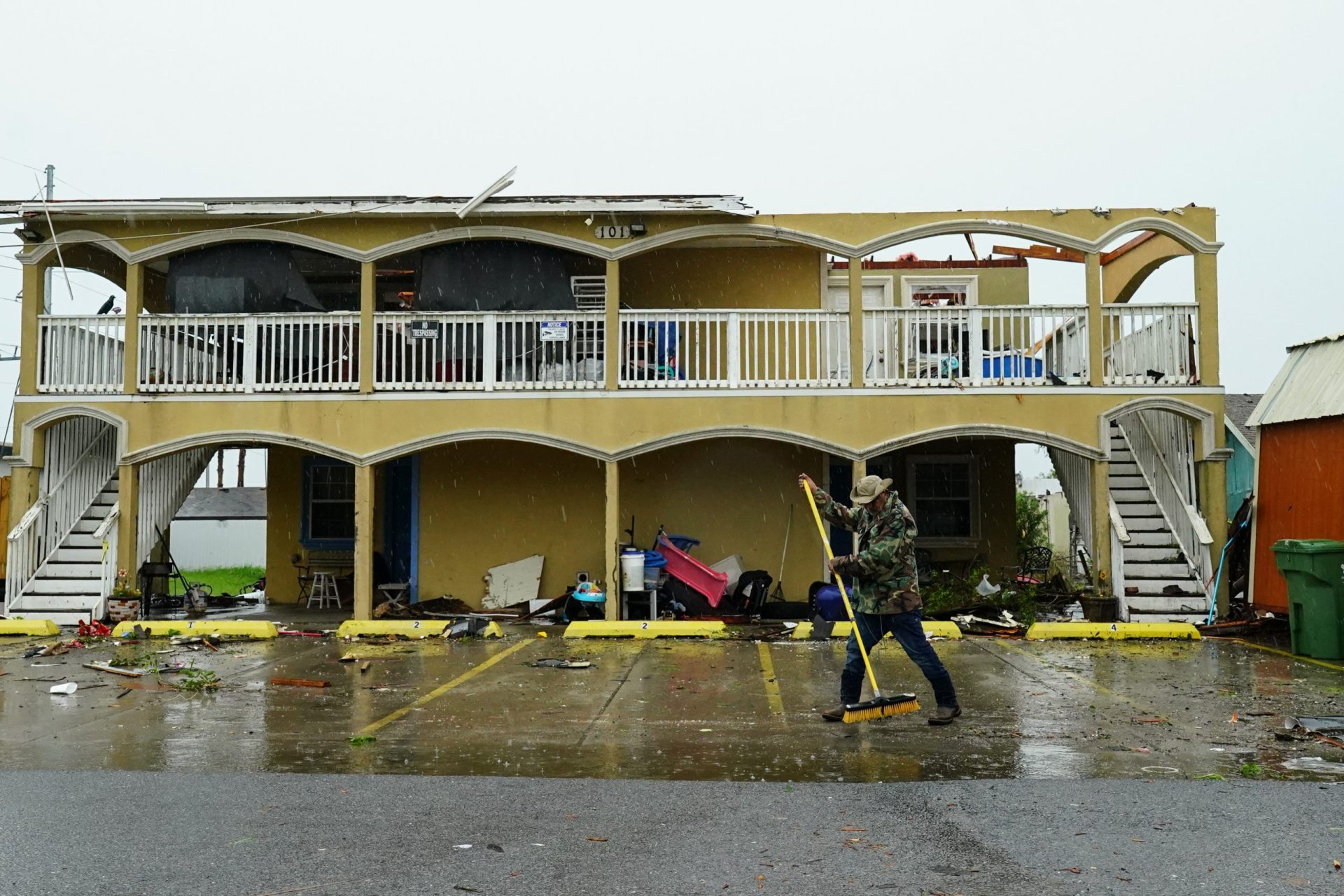
Those conditions have produced several weather events involving large or very large hail, squall lines producing winds up to 90 mph in some cases, the Laguna Heights tornado and of course lots and lots of rain. The period from March 28, when the heavy rain started, to June 5 is ranked among the top five wettest on record for the period for Brownsville Harlingen and McAllen, according to data from most of the Valley’s long-term recording stations, Goldsmith said.
More storms were forecast for June 6, though it appeared less likely by late afternoon Tuesday. Goldsmith said the soggy pattern of April and May is about to make an abrupt exit, and predicted a potential repeat of brutal July-August 2009 with its rare triple-digit averages or something close to it.
“This year has a lot of similarities that are concerning, especially since people have gotten used to … storms cooling things off and allowing for nice temperatures overnight,” he said. “We’re going to get a taste of that potential summer searing heat beginning late this week and really peaking over the weekend and into early to mid next week.
“We’re talking numbers that would be especially at night and early morning, just super sultry, where the heat index at night won’t fall below 90 anywhere. We’re not used to it. We didn’t have a hot May.”
Thank the powerful high-pressure ridge shaping up for the Permian Basin through Chihuahua and Coahuila states in Mexico, then southeastward into the Valley and the Gulf, bringing with it “La Canicula,” the dog days, Goldsmith said.
“That set-up and that ridge pattern is coming, and it’s going to come pretty quick,” he said.


