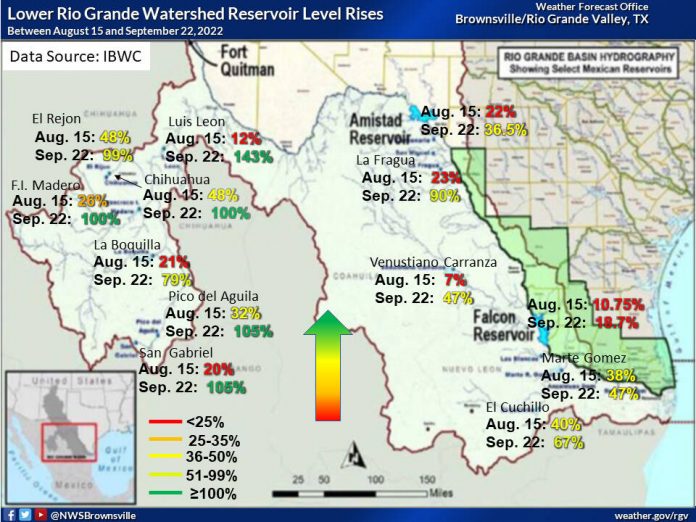
Amistad Reservoir continued to rise steadily throughout the past month, according to Barry S. Goldsmith, NWS warning coordination meteorologist.
In an email, Goldsmith said that the reservoir near Del Rio is now at 36.5% total share, an increase of 22% from Aug. 15.
“There is no change in the expectation that Amistad will exceed 40% in the next week to 10 days (due to continued inflows from the Rio Conchos into the Rio Grande near Presidio) before a slow-down in the rise, then a likely leveling off later in October – barring any unforeseen eastern Pacific tropical cyclone remnants,” the email read.
According to Goldsmith, Falcon International Reservoir remained at 18.7% total share, up from 10.75% just over a month ago.
“There is no change in the expectation that Falcon will remain level for the next week or so before beginning a slow decrease thereafter – barring any unforeseen eastern Pacific tropical cyclone remnants,” he said in the email.
The meteorologist went on to say that the Rio Grande Valley can expect drier air throughout the entire region next week as a result of a tropical cyclone and the season’s first dry front.
“Until then, the ‘lower’ and perhaps ‘mid’ Valley (Cameron/Willacy/Hidalgo) may see isolated showers to perhaps scattered showers ahead of the dry front, with the best chances early next week,” Goldsmith said in the email. “These rains will not reach the inflow region of the Lower Rio Grande watershed.”
The area of western Hidalgo County to the southern and central parts of Starr County and southern Zapata county are expected to have the highest rain total by the end of September. Most of the Valley will have lower rainfall totals, as well as Jim Hogg and Kennedy Counties.
“The latest 6 to 10 day and 8 to 14 day precipitation forecasts, issued on September 22 but valid into the first week of October, show increasing confidence of little to no rainfall across the watershed and the Rio Grande Plains,” the email read.
Hitting a low point: Drought, treaty noncompliance continue to stress RGV water supply
Despite the rising levels at Amistad and Falcon Reservoirs, they are anticipated to level off near the 30 or 40% range, a number that is still below the long term average.
“With Falcon expected to begin falling again, it behooves the region to continue to conserve and use water wisely through autumn and into winter and especially spring 2023,” Goldsmith said.
He also urged continued wildfire prevention through the end of the year.
“Lush, green grass and brush can quickly become ‘crispy’ and be ready to burn – fast,” the email read.
He also added that sharp temperature drops are a possibility for the months of October through December.
“Even during an above to much-above average October-December, one or two sharp cold fronts can change apparent, or ‘feels like’, temperatures by more than 40 degrees from one afternoon to the next,” he said. “The best opportunity would be between Thanksgiving and New Year’s Eve. Examples include one afternoon feeling like the upper 80s, and the next afternoon the lower 40s. While we can’t explicitly forecast this potential now – and there’s no guarantee it would occur until 2023 – folks should be prepared as we move later into autumn and early winter.”
Drier weather to close out month; reservoirs still very low in South Texas
He referred to Autumn as “King Tide Season”, a time when tides coincide with prolonged and strong wave energy from the east and northeast.
Tidal ‘run-up’ and minor coastal (beach) flooding can occur,” the email said. “We’ve had several events the past two Octobers and Novembers; next week (September 28-October 2) and perhaps beyond will be our first event in 2022.”
High surf and dangerous rip currents are guaranteed at some point while the surf temperature is expected to remain at 80-degrees or higher.
“Beachgoers should be aware of dangerous surf; city and businesses with equipment on the beach should be ready to stow it behind the dunes as conditions warrant,” Goldsmith said.
He added that strong fronts and cold northerly winds could be troublesome for pelicans along Padre Highway near the vicinity of Gayman Bridge.
“This situation could arise in late November and December, so travelers between Brownsville and Port Isabel should be alert following such fronts,” the email read.


