

HARLINGEN — Every summer the high-pressure ridge that sits over West Texas and northern Mexico is a real bully when it comes to driving gulf moisture away from the Rio Grande Valley.
This summer isn’t the exception.
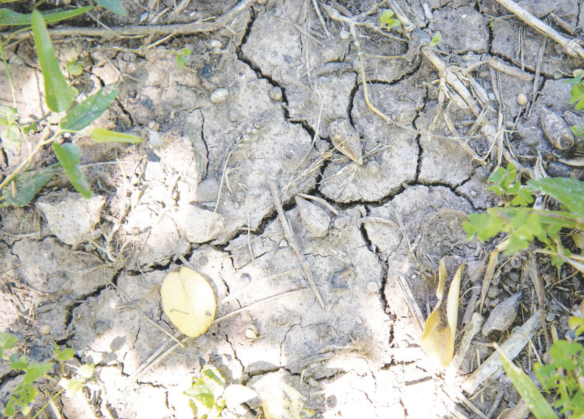
West Cameron County and most of Hidalgo County are listed this week as being abnormally dry by the U.S. Drought Monitor index, with southern Hidalgo listed in the higher category of moderate drought.
“It’s not uncommon for this time of year as far as drought goes,” said Julie Lesko, forecaster with the National Weather Service in Brownsville.
“The ridge of high pressure that sets up over the western part of the region, that extends all the way back to the desert southwest, that really puts a capping situation on our rainfall, and any tropical moisture that comes into the region gets pushed around by that high pressure,” Lesko said yesterday.
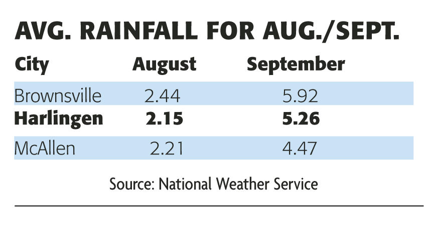
For the year, Brownsville is about where it should be when it comes to precipitation, with the city receiving 11.66 inches of rain, with 12.14 inches of rain the average amount for the year.
But farther up the Valley, things aren’t quite that normal.
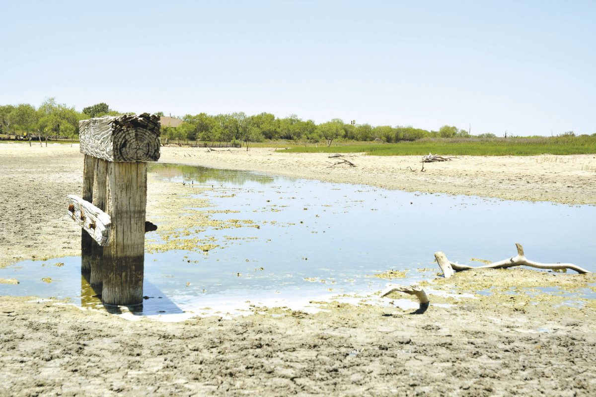
Harlingen, despite receiving a welcome 0.86 inches of rain officially this week (some areas of the city received as much as a half-inch more), sits at 9.65 inches of rain for the year. Normally, that would be 12.16 inches.
Last year at this time, Harlingen had received 12.11 inches of rain.
In McAllen, things are very dry. The city has received only 6.23 inches of rainfall for the year, which is a little more than half of the 11.17 inches which normally falls. Last year, the city had seen 8.46 inches of rain by now.
“We are not necessarily unusually dry for this time of year,” Lesko said, “but for some areas where we had a dry spring this is sort of a holdover.”
The dry lawns and the crunchy gardens should be in for some relief, however. The Rio Grande Valley is considered to be the southernmost tip of the American Great Plains region, and beginning in August and through September we can expect showers.
“It usually doesn’t continue too much longer,” Lesko said. “By mid-August the pattern does shift, and by August into September we get into more of a wet season with September being one of our rainiest months.”
As the high pressure out west fades into the late-summer sunset, we increase our chances of seeing tropical systems — for better or worse.
“These are the months, August and September, when we are likely to see tropical systems impact the Rio Grande Valley and Deep South Texas,” Lesko said. “It’s really going to depend on how the pattern changes when the gulf and Caribbean moisture opens up to us, or whether or not we see any tropical systems.”
For the next week or so, we can expect more of the same — dry and hot.
Last week temperatures at Falcon Dam hit 109 degrees, and Lesko said we may see more of that type of thing up and down the Valley. Highs between 96 and 107 are predicted this weekend.
“The weather pattern, depending on which model you go by, looks like it’s going to shift a little bit,” Lesko added, saying a troughing system over the West Coast could mean chances of showers and thunderstorms increasing to 20 to 30 percent by the start of next week.
“That doesn’t mean our hot and dry period is over,” she said, “it just means we could see some chances of rain, and it could get hot and dry again.”
A few areas of above-normal precipitation con-tracted D0 (abnormally dry) in parts of Texas, but most areas in the South had less than half an inch of rain, with many locations reporting no rainfall.
Source: U.S. Drought Monitor
September in most years is when average rainfall spikes to between 4.5 and 6 inches, Valley-wide — and when the Bermuda/western Atlantic ridge typically “takes over” and opens the door to the necessary tropical moisture to produce multiple events of locally heavy rainfall, whether or not a tropical cyclone is associated.
In 2016, La Canícula (Spanish for the dog star, used to describe hot days of late summer) held forth and rainfall was just 25 percent to 75 percent of average most places in the RGV. This could be the case again in 2017.
However, with some puzzle pieces still in place for a more active tropical season, including a neutral El Niño/Southern Oscillation, warm Atlantic Ocean temperatures and a mixed opportunity for low wind shear in the Caribbean and gulf, the northwest gulf will need to be on the lookout for bigger rains.
Stay tuned, but as always, be prepared for tropical moisture that could produce flooding rains from mid-August through the end of September, as always.
Source: NWS Brownsville


