

A shockingly fast drop in both temperature and humidity at the end of the week will pose a threat to people, crops and wildlife.
Temperatures throughout the Rio Grande Valley are expected to plummet with lightning speed Thursday night into Friday morning, according to meteorologists with the National Weather Service in Brownsville.
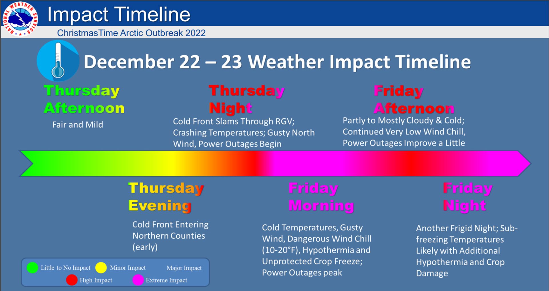
“‘Sharp change’ is the big story here to start. A 60- to 65-degree drop in ‘apparent’ temperature between the afternoon of Thursday and the morning of Friday. That’s an 18-hour time frame,” NWS Brownsville Meteorologist Barry S. Goldsmith said during a webinar Tuesday afternoon.
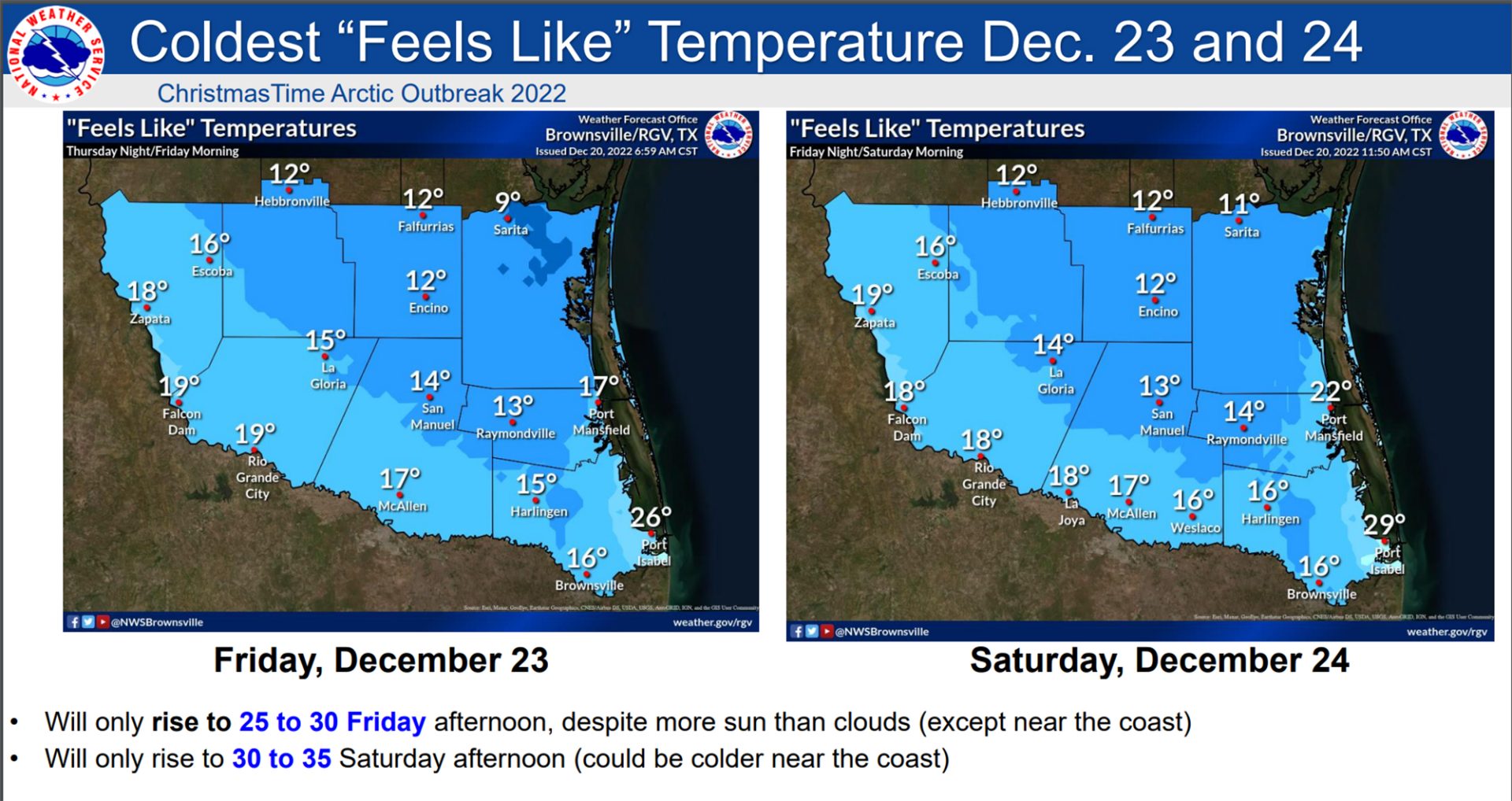
Temperatures will drop from the low 70s on Thursday to 28 degrees Fahrenheit or lower by early Friday morning, Goldsmith said.
The front will serve up a one-two punch. Temperatures will first go into free fall heading into Friday morning before warming slightly during the day. Then, they will drop below freezing again Friday night into Saturday morning.
Strong winds and extremely low humidity will worsen conditions.
“We’re expecting winds to really crank up behind this front to 25-35 mph with a few gusts of 50 mph soon after sunset Thursday and will continue for several hours everywhere, especially the Lower, Mid-Valley, and then all night toward the coast,” Goldsmith said.
Those wind gusts may cause damage to roofs or other objects, and may cause power outages throughout the region.
Combined, those three variables — temperature, wind and humidity — will create life-threatening conditions for people, pets, livestock and more.
“The hypothermia threat is real. And if people aren’t prepared or have a way to get to a heated area, it really does increase the threat for death,” the meteorologist said.
Windchill — or “feels like” temperatures — will dip into the teens, with all four counties expected to feel as cold as 10-20 degrees.
But what could likely spell doom for the citrus industry — which has been gearing up for its first strong winter harvest in more than two years — is a precipitous drop in relative humidity.
That “crash” in humidity will create single-digit or below zero dew points, which will cause the moisture inside oranges, grapefruit and other citrus crops to turn into ice as it evaporates.
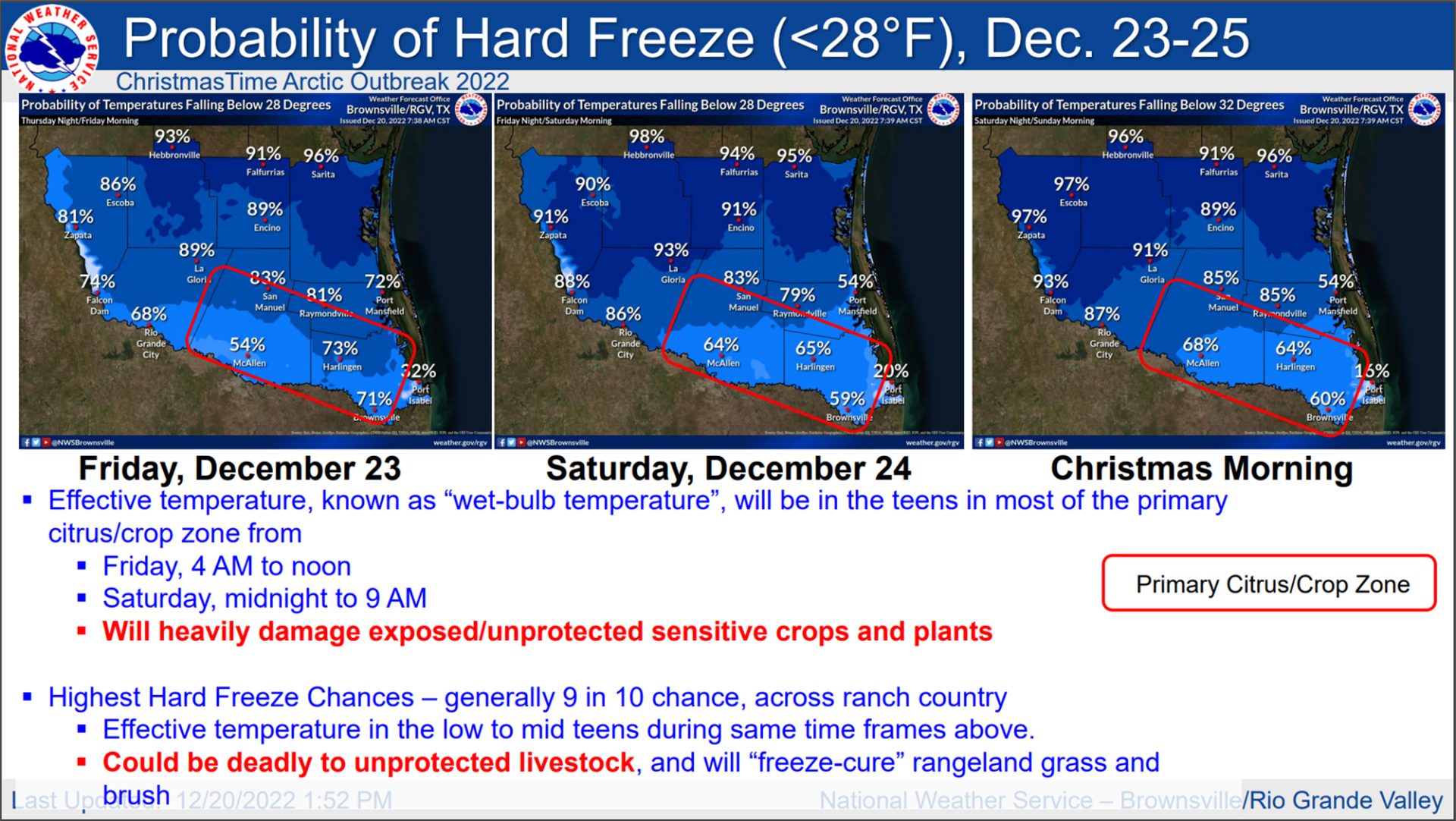
It remains unclear how many of the Valley’s citrus groves will be affected, but Goldsmith put the chances of a “hard freeze” at between 50 and 80% on Friday, which is expected to be the coldest day.
Hard freeze chances will remain high through Christmas morning, Goldsmith said.
“Friday night (will be) another frigid night with sub-freezing temperatures everywhere. And we’ll have to watch for additional hypothermia and the crop damage will continue as the repeated cold air is a real death blow to unprotected crops and plants,” Goldsmith said.
The cold snap will also threaten livestock and local wildlife.
In the ranchlands just north of the Valley, livestock will need to be protected indoors as temperatures there could fall into the low 20s.
And along the coast, scores of sea turtles are expected to become “cold stunned” as water temperatures in both the Laguna Madre and the Gulf of Mexico nearshore will fall below 50 degrees Fahrenheit.
At that temperature, the reptiles’ bodies enter a catatonic state that can result in death without human intervention.
“This will require a mass rescue,” Goldsmith said.
He added that thousands of sea turtles may be affected along the coastline here, while tens of thousands could be impacted across the entirety of the state’s 367-mile coastline.
The marine forecast looks bleak, as well, with offshore waves nearly 20 feet high and 10-15 feet inshore, Goldsmith said.
Between the waves and gale-force winds, as much as half to two-thirds of South Padre Island’s beaches may be stripped.
Though conditions over the holiday weekend will be dangerous Valleywide, the forecasts do not predict that precipitation will be a factor, meaning it’s unlikely we’ll see hazards like icy roads.
Further, though the conditions will cause losses to the current citrus crop — and potentially loss of foliage — the trees themselves should be able to withstand the front.
“The trees are very hardy. They can get down to 14 degrees,” Goldsmith said.
The meteorologist advised people to finish their cold weather preparations before sunset on Thursday. He reminded them of the “four Ps” — people, pets, plants and pipes.
“A 60-65 degree ‘feels like’ temperature drop in just 18 hours. This is as sharp as it gets, folks. I haven’t seen one this sharp since I’ve been here,” Goldsmith said.
“This one means business.”


