
McALLEN — Residents might have a new representative on the city commission after city leaders adopted changes to the city’s districts.
The McAllen city commission approved new district maps Monday following a months-long process to redistribute the city’s population among the six districts.
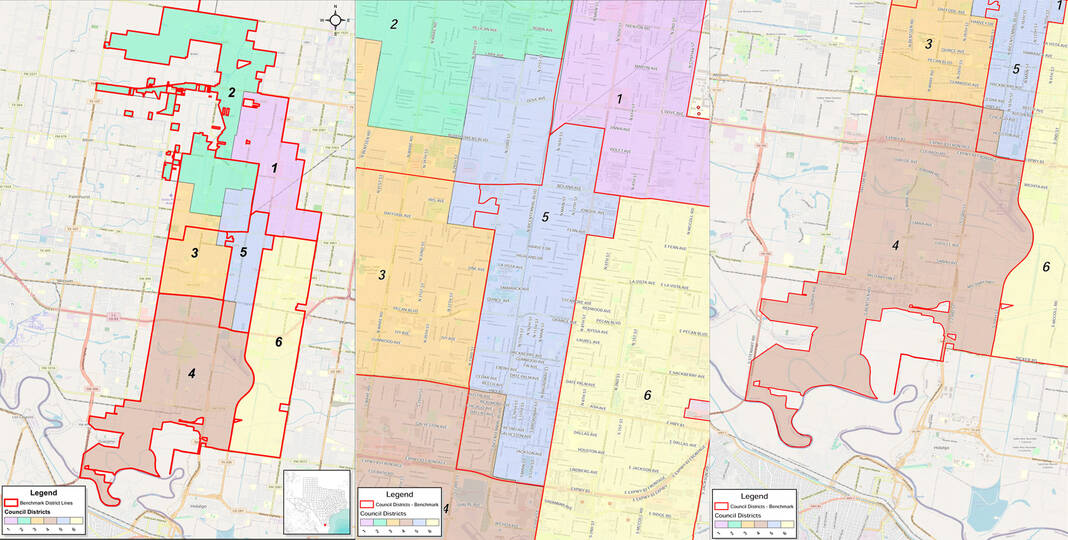
As approved, the new geographical boundaries shift a large portion of District 1 over to District 2 while District 3 shifts to the north and northwest, City Attorney Isaac Tawil explained to the commissioners during a special meeting on Monday. District 5 expanded slightly northwest while District 4 expanded slightly into the southwestern side of District 5.
Redistricting is required to update single-member districts every 10 years following the U.S. Census.
The results of the 2020 Census showed that Districts 1, 2 and 6 were overpopulated and residents there had to be redistributed to the other districts.
As the city embarked on the process, they looked at three over-arching principles — making sure the districts represent a one person, one vote principle, that they complied with non-discrimination requirements of the Voting Rights Act, that they did not manipulate district lines so as to gerrymander them, and that they looked at the Voting Rights Act at Section 5 with respect to retrogression which is leaving a racial or ethnic minority worse off than they were before in terms of voting strength.
In May, the city commissioners adopted requirements for the new district maps:
>> having identifiable boundaries
>> maintaining communities of interest and neighborhoods
>> using whole voting precincts, if possible
>> basing the plan on existing districts
>> adopting districts of relatively equal size
>> drawing districts that are compact and contiguous
>> keeping existing incumbent city commissioners within their districts
>> narrowly tailoring the plan to comply with the Voting Rights Act
One way to ensure the districts’ population are more or less equal to each other is to have the total deviation — or the difference between the actual population and the ideal population — be less than 10%.
The updated Census data showed the entire city of McAllen had an overall deviation of 48%. District 1, alone, had a deviation of about 31% while the city’s smallest district, District 5, had a deviation of -17%.
Under the adopted maps, the city’s overall deviation is approximately 4.19%.
District 6, which now has the largest population, has a deviation of 2.74% while District 1, now with the smallest population, has a deviation of -1.44%.
The approved maps, labeled Plan A-1, were one of three proposals that were presented to the city commissioners for consideration.
The selection of Plan A-1 over the other two proposals — Plan A and Plan B — was because the commissioners wanted to focus on making the districts as even as possible with the current population as opposed to focusing on future growth, according to District 5 City Commissioner Victor “Seby” Haddad.
“They were both kind of accomplishing the same result but just sort of in (a) different matter,” Haddad said of Plan A and B. “The reason we went with what we call A-1, which is a modification of Plan A, is because Plan B was sort of creating maps that tried to create deviation to allow for certain growth in the future, so allow them to even out even a few years in the future.”
But he said the commission felt that the point of redistricting was to even out the districts today.
“When we came up with Plan A-1, it was not only with community feedback but it was the commission itself looking at the various lines and how they felt we could best accommodate evening out the populations,” Haddad said, “but (also) trying to keep the representation of the districts fair and ensuring that each district was well-balanced and didn’t stretch too far north and too far south, they all had east and west boundaries that were fair, and trying to keep them as even as possible.”
But over the course of the next 10 years, Haddad said the population is expected to grow dramatically on the north side.
“It will be interesting to see how our city shifts in the northwest as our population grows because that’s really where our city is growing, is north and northwest,” Haddad said.
District 6 Commissioner Pepe Cabeza de Vaca agreed that though he now has the largest population in his district, that’s only expected to change by the time the city has to redraw the district maps again.
“(Plan) A-1 seems very, very fair as far as population for each district. In this case, mine is going to be the largest district as far as population for the next 10 years,” Cabeza de Vaca said. “There’s a lot of growth in the city of McAllen, especially to the north, so that’s going to change probably in the next 10 years.”
He added the commissioners were pleased with the adoption of the new maps and the redistricting process.
“I think it was a good exercise, we had different recommendations, we looked at other recommendations, and I think we adopted the one that makes more sense for the districts involved,” Cabeza de Vaca said.
The new maps will go into effect once the ordinance adopting the new districts has been signed.
Haddad encouraged residents to familiarize themselves with the new maps and reach out with any questions.
“We invite the public to inquire and contact city hall, ask for the new maps as soon as they’re finalized, and just stay abreast of what we’ve got going on here,” Haddad said, “and they can reach out to any of the commissioners who will be happy to share what we have.”


