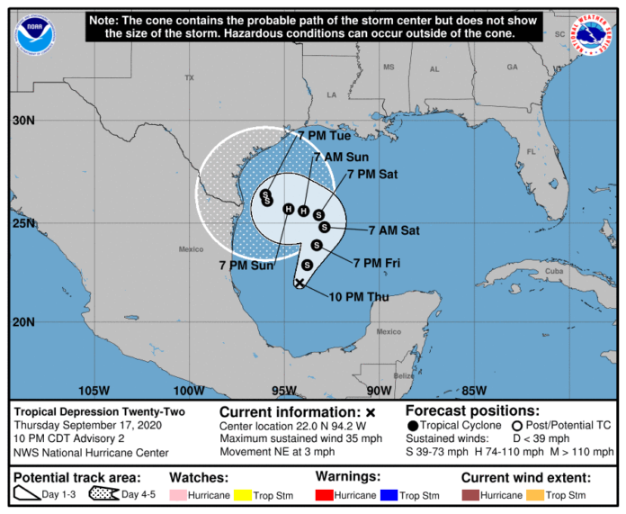
Although there are still over two months left in the 2020 Atlantic hurricane season, we are just about to run out of names for this year’s storms.
The 21-name list selected for this year by meteorologists is about to come to an end.
Wilfred, the last name on the list, could be used today or this weekend should the tropical disturbance in the Gulf develop into a tropical storm.
The last time all names were used on the list was in 2005. Forecasters will have to turn to names based on the 24 letters of the Greek alphabet such as Alpha, Beta, and so on.
The National Hurricane Center reported thunderstorm activity across the southwestern Gulf of Mexico continued to become better organized Thursday afternoon and that the atmospheric conditions were conducive for the development of a tropical depression over the next two days.
According to the NHC, the low is expected to meander across the Gulf into Friday before drifting north to northeast over the weekend.
The National Weather Service in Brownsville states although it’s unknown where the center will form and track, the disturbance could bring heavy rain chances with potential flooding to the Rio Grande Valley. Gusty winds and hazardous marine and coastal conditions could also occur.
The NWS states there could be coastal flooding and beach erosion as well as dangerous surf and rip currents.
Cameron County Judge Eddie Trevino Jr. will hold a press conference Friday morning that will focus in part on the weather conditions that will impact the area.
According to the NWS, confidence is growing that there will be ample tropical moisture brought to the Valley that could produce locally heavy rainfall later this weekend.
“This rainfall will be on top of what we have already received this week, and expect to see tomorrow, associated with an upper level disturbance over the region.”
Coastal flooding and erosion would begin as early as late Saturday, and peak Monday through Tuesday, or longer, forecasters said.
The lack of strong steering currents early next week could create a significant flood/beach erosion event on South Padre. Combined with prolonged heavy rainfall, total water flooding/impacts could be critical.
The NWS reports boating will also become hazardous when Waves/Seas/Swell will build beginning Saturday, and could reach 8 feet or more Saturday night through at least Monday. If a cyclone develops and moves into or near the area, wind and seas would be substantially higher.
There will also be hazardous swimming conditions.
The NWS reports rainfall amounts through next Thursday could total 4 to 6 inches of rain in the Brownsville area, 8 to 10 inches on rain around the South Padre Island area, 4 to 6 inches in the Harlingen, Raymondville and Port Mansfield areas, 3 to 4 inches of rain in the Weslaco area, 2 to 3 inches in the McAllen area, and 2 to 3 inches in the Rio Grande City area.
There’s a 70% chance of thunderstorms on Friday and 30% chance of scattered showers Friday night. There’s a 40 % chance of thunderstorms on Saturday and a 30 percent chance Saturday night.
The rain chances start to increase on Sunday with a 50% chance of showers of thunderstorms, and a 70 % chance of showers or thunderstorms on Monday and Tuesday as well. There’s a 60% chance of showers or thunderstorms on Wednesday.
The NWS reports coastal flooding could occur in Cameron and Willacy counties through Friday.


