The Rio Grande Valley has been in the crosshairs of many hurricanes and tropical storms in recent years, most recently Hurricane Hanna. With two storm systems heading toward the Gulf of Mexico this week, forecasters are predicting that the region will be out of the way, but there is still the possibility for some rain and a higher risk of rip currents in South Padre Island.
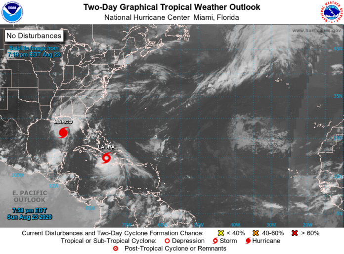
Marco, which was upgraded to a hurricane Sunday morning, is projected to make landfall in the area between Port O’Connor and Louisiana on Tuesday or early Wednesday, according to Barry Goldsmith, warning coordination meteorologist for the National Weather Service in Brownsville.
Tropical Storm Laura was east of Haiti and just south of Cuba on Sunday, but is forecast to enter the Gulf of Mexico on Tuesday.
With both storms entering the Gulf of Mexico, a phenomenon rarely witnessed, the two storms create a slim possibility for an even rarer phenomenon known as the Fujiwhara Effect.
“If Laura were to move faster and farther south, and get within 400 to 500 miles of (Marco), then they could interact with each other and apply some energy to each other,” Goldsmith said. “If they get really close, then it’s possible that one would try to circle around the other.”
Goldsmith that the Fujiwhara Effect could cause the storms to spin around each other, or it could cause the centerpoints of the storms to gravitate toward the other.
“Sometimes they can blend into one — one cyclone,” Goldsmith said. “We’re not expecting that to happen in this case, however.”
Goldsmith said that Marco could potentially bring some sea breeze showers to the Valley early on in the week, but more than likely most of the Valley will remain dry. He said that the storm systems could still cause high surf and rip currents on South Padre Island on Tuesday.
“Fujiwhara is really tricky to determine,” Goldsmith said. “They’d have to get a lot closer than they are, and the current forecast does not have that happening, but there are some models that are trying to do that — trying to get them within 500 miles of each other.”
According to Goldsmith, the last time there were two named storm systems in the Gulf of Mexico at the same time was in 1859.
“In 2004, we had Tropical Storm Bonnie and Hurricane Charlie,” Goldsmith said. “Bonnie actually dissipated by the time Charlie got into the Gulf, but that was close. They weren’t too far from being two named storms in the Gulf. But 1859 was the last time there were two named storms in the Gulf.”
“As far as I can understand, there’s not been a time, at least since 1859, where there were two named hurricanes in the Gulf at the same time. It’s been a while.”
With the projected forecast of both storms, Gov. Greg Abbott issued a state disaster declaration Sunday for 23 counties, including Cameron and Willacy.
In a news release, the governor said he was also requesting a federal disaster declaration ahead of the storms’ arrival.
“As Hurricane Marco and Tropical Storm Laura approach Texas, the state is taking necessary precautions to protect our communities and keep Texans safe,” Abbott said in the release. “I urge Texans in the path of these storms to plan ahead and heed the guidance of their local officials. The State of Texas is working with local and federal partners to monitor these storms and provide the resources our communities need to respond.”
NATIONAL HURRICANE CENTER: https://www.nhc.noaa.gov/gtwo.php?basin=atlc&fdays=2
NATIONAL WEATHER SERVICE BROWNSVILLE: https://www.weather.gov/bro/


