HARLINGEN — Cameron County’s emergency manager late yesterday afternoon issued a storm alert for South Padre Island residents, telling them to prepare for impact by the remnants of Tropical Storm Harvey.
Emergency Management Coordinator Tom Hushen advised residents on the Island to prepare for possible storm impacts ranging from heavy rain to rain and strong winds.
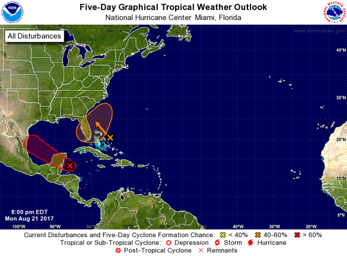
Demoted but not vanquished, the remnants of Tropical Storm Harvey continue to push toward the Yucatan Peninsula and a possible resurrection in the Bay of Campeche as it heads west.
Now, referred to as Invest 09L, the trough of low pressure is producing thunderstorms and showers in the Caribbean and forecasters are watching closely to see how it interacts with the Yucatan Peninsula as it crosses land.
About a dozen computer models, known as spaghetti models, have shifted over the past few days to the north. Of the dozen or so latest modeling runs associated with Invest 09L, several predict the tropical trough will head for South Texas.
“Although some indicate a minimal impact, there are a few models we are tracking that show a stronger storm that could make landfall at South Padre Island,” City Manager Susan Guthrie said in a statement. “We are taking steps to ensure we are prepared if the storm heads our way.”
The real question is just what Invest 09L will become after it arrives over the very warm Bay of Campeche waters early Wednesday. Conditions are expected to be more conducive for development then, forecasters say.
“It’s looking at more than water temperatures, which are just one piece of the puzzle, with wind shear and dry air,” Barry Goldsmith, meteorologist with the National Weather Service in Brownsville, said yesterday. “The news on this one is the dry air won’t be there, which is good for hurricanes, good for tropical systems.”
“As for shear, that enemy is not looking as pronounced as it had been when Harvey was struggling across the Caribbean,” Goldsmith said. “As far as wind shear goes, there is a thin pocket of low wind shear which is friendly to development.”
At this point, he said, it’s too early too tell just what Invest 09L might bring to the Valley.
But it will bring something, forecasters believe.
“We’re not going to know the answer to these questions until Wednesday morning,” he said.
Goldsmith said meteorologists were “fairly confident” that we can expect whatever is coming to arrive sometime Thursday night or Friday.
“This is tricky,” he said. “This could be a small storm and your area of impact can be relatively small as well.
For example, Tropical Storm Hermine in 2010, Hermine went straight up Highway 77 through Brownsville, Harlingen and Raymondville.
“But if you were in McAllen, you said, ‘What storm?’”


