
Tropical moisture making its way to the Rio Grande Valley could lead to possible flash flooding from Saturday through Monday, the National Weather Service in Brownsville/Rio Grande Valley is reporting.
The NWS reported Wednesday that tropical moisture combined with a stalled/washing out frontal boundary and weak atmospheric disturbances, should lead to heavy periods of heavy showers and some thunderstorms.
Weather forecasters are urging residents to begin taking precautionary measures before the heavy rain arrives. These measures include removing debris from drainage ditches, cleanouts, and canals by mid-day Friday. Motorists should check the tire tread and pressure and repair/replace; check brake pads/shoes for wear and replace if needed; check windshield wipers for dry rot and replace immediately to give a clear view.
Flood watches may have to be issued by the end of the workweek, the NWS reports.
The rain chances begin to increase Friday and then “really ramp up for Saturday and Sunday, with flash flooding a possibility,” Josh Schroeder and Brian Miller, meteorologists at the NWS, stated in an email.
In the Brownsville area, there’s a 60% chance of heavy rain Friday, and a 70% chance of heavy rain Friday night. There’s a 90% chance of heavy rain Saturday and Saturday night, and an 80% chance of heavy rain Sunday and Sunday night. There’s also an 80% chance of heavy rain Monday.
In the Harlingen area, there’s a 50% chance of heavy rain Friday and Friday night, and an 80% chance of heavy rain Saturday and a 70% chance of thunderstorms Saturday night. There’s a 70% chance of heavy rain Sunday and Monday.
In the McAllen area, there’s a 50% chance of heavy rain Friday and a 40% chance of thunderstorms Friday night. There’s an 80% chance of heavy rain Saturday and a 60% chance of thunderstorms Saturday night. There’s a 70% chance of heavy rain Sunday and a 60% chance of rain Sunday night. There’s a 70% chance of heavy rain Monday.
The weather pattern appears to hold into at least early next week, including the Labor Day holiday.

According to the NWS, Thursday will bring typical sea breeze showers but by later in the day Friday, tropical moisture will begin to surge into Deep South Texas with scattered showers and thunderstorms that could lead to possible ponding of water on the roadways and nuisance flooding.
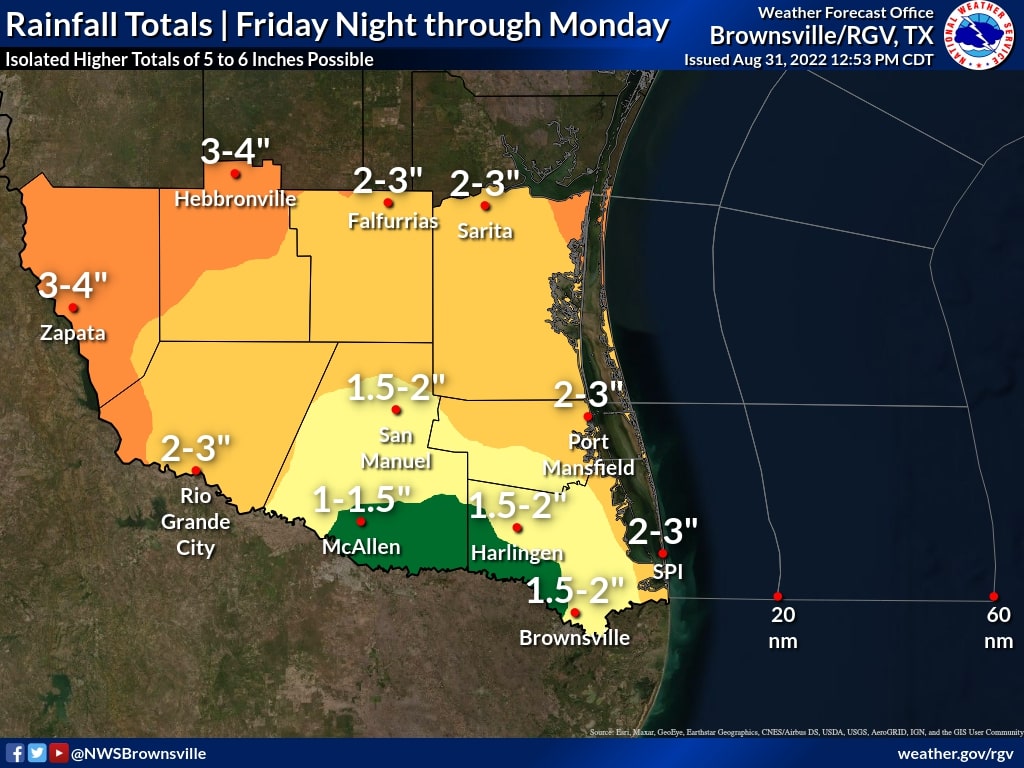
Rainfall totals for Friday through Monday could reach 2-4 inches “pretty much anywhere in the RGV/Deep South Texas,” the NWS reports. Isolated totals of 5-6 inches are possible. However, there is uncertainty as to where the highest totals will be, which depends on the smaller-scale organization of storm clusters.
The NWS, reports that the Weather Prediction Center has included much or all of Deep South Texas and the RGV in a “Slight” risk area of their experimental Excessive Rainfall Outlook for Saturday.
Total rainfall of 2 to 3 inches over a couple hours in poor drainage areas of the Valley could result in 1 to 2 feet of water depth and nuisance flooding, the NWS reports.
Saturday through Monday there is the potential of 2-3 inches of rain in an hour across poor drainage locations that could result in 2 to 3 feet of water depth with street flooding, minor vehicle damage, and some water into exposed buildings, the NWS reports.


