
As rain begins to fall Sunday across the Rio Grande Valley, officials with the National Weather Service in Brownsville report that the rainfall may continue to persist into the midweek.
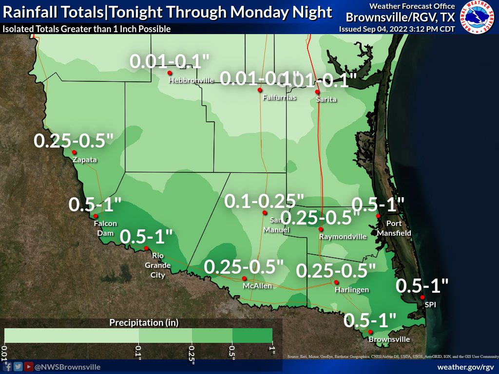
The NWS reported the heaviest rainfall began Sunday and will continue into Monday, with localized nuisance flooding likely and possible flash flooding.
Moreover, the conditions are expected to continue into the midweek, the NWS reports, though the rain is expected to be in lesser amounts for Tuesday and Wednesday.
For potential impacts, officials said Sunday through Wednesday may potentially have 2-3 inches of rain in an hour across poor drainage locations, which could result in 2 to 3 feet of water depth with street flooding, minor vehicle damage, and some water into exposed buildings.
They also warn that driving could be difficult in heavier downpours with near zero visibility at times. Furthermore, they said drivers should be planning alternate routes away from ones that typically flood when it rains like this.
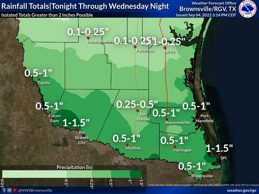
Rainfall totals through Wednesday could reach 2-4 inches “pretty much anywhere” across deep South Texas, with locally higher amounts possible, though there is uncertainty as to where the highest totals will be, the NWS reports.
Here are the risks levels provided by the Weather Prediction Center for all of deep South Texas and the RGV:
>> A “slight” risk area of their experimental excessive rainfall outlook for Sunday through Monday;
>> A “marginal” risk for much of the area on Tuesday, with a “slight” risk across the Cameron and Willacy counties;
>> and a “marginal” risk on Wednesday for much of the region.
As the NWS continues to monitor the situation, they said that a flood watch looks unlikely at this point, but will re-evaluate as needed. Sunday’s update will be the last update for this event, unless major changes are made to the forecast, the NWS said.
As of Sunday, here are region specific updates provided by the NWS.
WILLACY COUNTY AND NORTHWESTERN CAMERON COUNTY
A strong thunderstorm will impact portions of south central Kenedy, northwestern Cameron and western Willacy Counties through 2:45 p.m. Sunday, the National Weather Service in Brownsville/Rio Grande Valley reported in a special weather statement.
At 2:05 p.m., Doppler radar was tracking a strong thunderstorm near Raymondville High School, or near Raymondville, moving north at 20 mph.
Winds in excess of 30 mph could knock down tree limbs and blow around unsecured objects.
Locations impacted include Raymondville, Lyford, Sebastian, San Perlita, Reber Memorial Library, Yznaga, Porfirio, Raymondville High School, Raymondville Police Department and Willamar.
Torrential rainfall is also occurring with this storm and may lead to localized flooding. Do not drive your vehicle through flooded roadways.
SOUTHEASTERN CAMERON COUNTY
A strong thunderstorm will impact portions of southeastern Cameron County through 1 p.m. Sunday, the National Weather Service in Brownsville/Rio Grande Valley said in a special weather statement.
At 12:20 p.m., Doppler radar was tracking a strong thunderstorm over South Point, or near Southmost, moving north at 20 mph.
Locations impacted include Los Fresnos, Rancho Viejo, Southmost, Olmito, Port of Brownsville, Cameron Park, Downtown Brownsville, Brownsville, Lincoln Park and Longoria Elementary School.
Winds are estimated at about 30 mph and could knock down tree limbs and blow around unsecured objects.
Torrential rainfall is also occurring with this storm and may lead to localized flooding. Do not drive your vehicle through flooded roadways.
This story will be updated as more information becomes available.


