
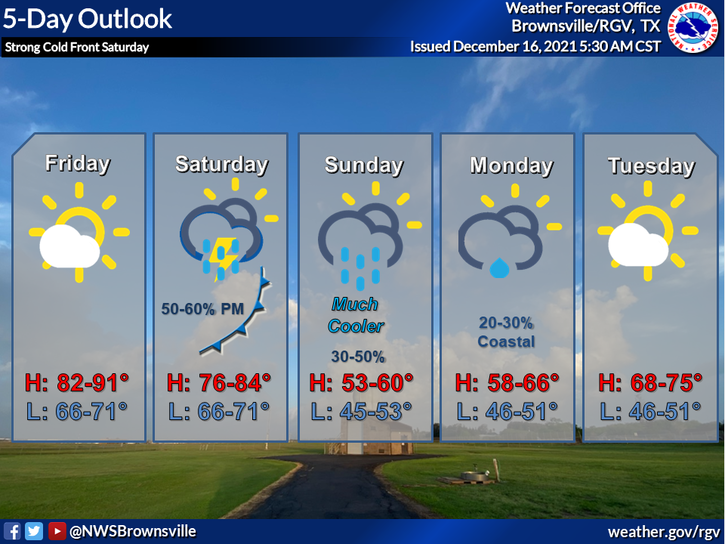
If these warm temperatures don’t have you in the holiday spirit, the weekend’s coming drop in temperatures might do the trick.
Another cold front will arrive in the Rio Grande Valley sometime Saturday afternoon, lowering temperatures into the 50s on Saturday night and continuing in the 50s on Sunday.
“There will be a little bit of taste of fall and winter again,” said Rick Hallman, a meteorologist with the National Weather Service in Brownsville, on Thursday. “The front comes through on Saturday. Right now, it’s looking like it is going to come through a little bit later in the afternoon.”
Hallman said the temperatures won’t drop that quickly. It will be in the low 80s Saturday afternoon and dipping down to the low 50s overnight.
There’s a 50% chance of showers or thunderstorms on Saturday and an 80% chance of light showers Saturday night. The showers could continue into Sunday and Monday, Hallman said.
“Sunday during the day it (the temperatures) might not move very much. We will start out in the low 50s and it may only get into the mid or upper 50s for the afternoon,” he said. “It will be a welcome relief from some of the heat for some.”
The cooler temperatures won’t last that long. Monday’s high will be around 61 degrees and Tuesday’s high will be near 72. The temperatures will continue to warm for the rest of the week.
Hallman said the warm temperature the Valley is experiencing right now is due to a pattern that is keeping the area warm.
“Overall, we are in an El Nino year too, that kind of leans a little bit more warm to us,” Hallman said.


