|
Only have a minute? Listen instead
Getting your Trinity Audio player ready...
|
By RICHARD TRIBOU AND ROGER SIMMONS | ORLANDO SENTINEL
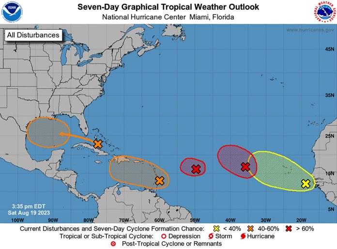
ORLANDO, Fla. — The National Hurricane Center got even busier Saturday when it announced that Tropical Depression Six had formed from among five systems it has been monitoring across the Atlantic and Caribbean.
In a 5 p.m. advisory, the hurricane center said Tropical Depression Six was located about 855 miles east of the northern Leeward Islands with maximum-sustained winds of 35 mph.
“The depression is moving toward the west-northwest near 16 mph, and a turn to the west is expected later today [Saturday] with a gradual decrease in forward motion over the next day or so,” the forecasters said. “On Monday, the depression is expected to turn back to the west-northwest.”
The hurricane center said the depression will encounter unfavorable conditions over the next day or so, and it is expected to dissipate by late Monday or Tuesday.
Meanwhile, the NHC said it’s likely a second tropical depression may form from a system located several hundred miles west of the Cape Verde islands. Forecasters give it a 70% chance of reaching depression status over the next 48 hours.
“Environmental conditions appear generally favorable for further development of this system, and a short-lived tropical depression is likely to form this weekend while it moves west-northwestward or northwestward at about 10 mph across the eastern tropical Atlantic,” the NHC said.
Like Tropical Depression Six, this system is also expected to face increasing upper-level winds that will limit further development.
A third system near the Windward Islands has a “medium” chance to also become a tropical depression later this week. That area of weather, given a 40% chance to develop into a depression in the next 48 hours, is moving westward to west-northwestward at 10 to 15 mph, across the Lesser Antilles and over the eastern and central Caribbean Sea.
Closer to home, an area of disturbed weather located near the northwestern and central Bahamas is expected to move into the Gulf of Mexico early this week. As it moves away from Florida, it has a 10% chance of strengthening into a depression in the next 48 hours, and a 50% chance in the next seven days.
Finally, a tropical wave emerged off the coast of Africa with a large, disorganized area of rain and storms. It has a 20% chance of becoming a depression in the next seven days as it moves west-northwest across the tropical Atlantic.
If any of the systems grow to named strength status, they could become Tropical Storm Emily with Tropical Storm Franklin, Tropical Storm Gert, Tropical Storm Harold and Tropical Storm Idalia next in line.


