MISSION — The rivers of Texas run with history.
From the Sabine and Trinity to the Brazos and Nueces, these waterways serve as markers used by explorer and historian alike to triangulate where we’ve been, to locate our place in time.
Perhaps the most storied of these is our river, the Rio Grande.
Unlike most rivers, the 1,896-mile Rio Grande becomes smaller the farther it flows from its headwaters in the San Juan Mountains in southern Colorado to the Gulf of Mexico.
Part of that is by design, an effort by humankind to tame the river’s devastating past floods and bring irrigation to the often arid farmland on both sides of the boundary river that separates Mexico and the United States.
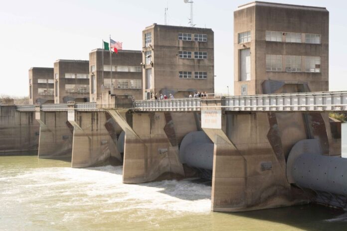
A microcosm of that long international border is found in the control room of Tower 4 at the Anzalduas Dam near Mission. It’s the middle tower of seven that contain six gates that are 75 feet wide by 21 feet high, and weigh approximately 140 tons apiece.
In the room, which is say 35 feet by 12 feet wide, a phantom border separates the two countries and the operators of the dam, one from Mexico, the other from the United States. The walls of the room are lined with monitors, recording and spewing back flow rates and other data used to monitor the dam.
“This is the desk for the operator of the U.S. side, and this is the desk for the operator of the Mexico side,” Emilio Garcia says, pointing from one country to the next as his feet nearly straddle the border.
“There’s always two operators,” says Carlos Chapa, who like Garcia is one of the operators for the U.S. side, working for the International Boundary and Water Commission.
“Two operators,” interjects Garcia, finishing the sentence for Chapa, probably a common occurrence between men who work in such close quarters as the cramped control room.
“A Mexican and a U.S. operator working here 24 hours a day,” Chapa continues. “That’s three shifts.
“We don’t have lives,” Chapa says with a little grin.
The occasion for this visit was a rare occurrence, a chance to tour the Anzalduas Dam. Security there was increased after 9/11, and those in the group taking advantage of the tour were told photographs in the control room were absolutely forbidden.
The room is cramped, and no colorful artwork adorns the little wall space that is clear. The control room’s meant for serious business, and it looks the part. The broad window to the east, though, provides a spectacular view of the white rapids and riffles that flow over and around the rocks below the dam.
The dam tour was led by Joe Tucker, the 89-year-old engineer and Valley native who spent 31 years of that time working at Anzalduas Dam for the International Boundary and Water Commission.
“They were glad to see me retire,” Tucker says of the IBWC. “When they were wrong, I’d tell them so.”
Construction of the Anzalduas Dam began in the early 1950s, and it was finished in 1960. Unlike Falcon Dam, or Amistad Dam, Anzalduas Dam is what is known as a diversion dam. The other two larger dams are power-generating facilities, but they also serve as storage dams.
“It’s a small dam compared to Falcon or Amistad,” Tucker says. “Falcon and Amistad store water and do generate electricity. Not all the time, the releases are not constant.”
Diversion dams for ag, flooding
Diversion dams have the dual purpose of guiding water from the Rio Grande into both countries for agricultural use, and to mitigate flooding of the lower Rio Grande Valley.
Anzalduas, named for a family that lived in the area in the 1950s, and Retamal Dam south of Donna were built to be crucial components of the Valley’s flood-control efforts, Tucker says.
Tucker says that even though the Valley appears flat, the land ever so slightly drains to the northeast in the United States. In Mexico, he says, it drains just slightly to the southeast.
Water always finds a lower level, he says.
“The watershed here in the Valley is very narrow because the land slopes away from the river. It’s not totally flat. It’s virtually flat, but not totally,” Tucker says.
To guide that water to the right spot, Tucker says there are about 270 miles of levees on the United States side of the border, with about 100 miles along the Rio Grande and the rest along interior floodways that channel floodwaters away from populated areas.
The flood-control project is meant to handle a flood rate of 250,000 cubic feet per second measured at Rio Grande City, and only 20,000 cfs can reach Brownsville, he said. By treaty agreement, each nation is obligated to divert half of all the floodwater in excess of what Brownsville can carry into the interior floodways.
For the rest of this story and many other EXTRAS, go to our premium site, www.MyValleyStar.com.
Subscribe to it for only $6.99 per month or purchase a print subscription and receive the online version free, which includes an electronic version of the full newspaper and extra photo galleries, links and other information you can’t find anywhere else.


