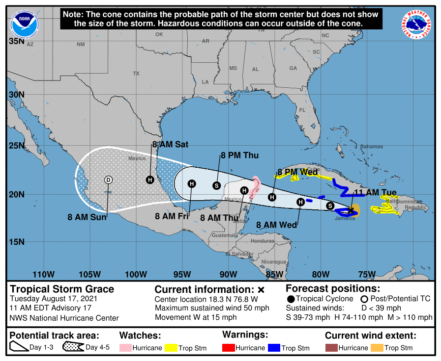
What was still Tropical Storm Grace Tuesday afternoon was predicted to become a hurricane today before making landfall near Cozumel, Mexico, late tonight or early tomorrow morning, weaken as it passes over the Yucatan Peninsula, then regain Category 1 status over the Bay of Campeche before making landfall north of Tampico, Mexico, early Saturday morning.
Tampico is roughly 250 miles south of the mouth of the Rio Grande as the crow flies, and forecasters expect the impact on the Rio Grande Valley to be fairly mild, though it could bring heavy rain lower-to-mid Valley starting late Friday and higher than normal surf along the coast and rough seas in the Gulf later in the week into the weekend.
Geoff Bogorad, senior forecaster with the National Weather Service Brownsville/Rio Grande Valley station, said Tuesday morning, as Grace was about to pound Jamaica with heavy rainfall, that the storm was getting more organized as it moved over the “very warm waters of the Caribbean” and with atmospheric conditions favorable for strengthening. The storm’s track hadn’t deviated much from earlier predictions, he added.
“We might see some outer rain bands move across Friday night into Saturday,” Bogorad said. “Any of those rain bands could bring some gusty winds and some brief, heavy rainfall. Most of the impact will be along the immediate coast, where we’ll see some higher seas offshore, maybe six to 10 feet on the waves. There might be some high surf breaking along the coast and some tidal overwash or run-up of the tides.
“It’s not going to be a good day to go to the beach on Saturday more than likely. Rip current risk will probably be high to extreme. Of course that’s dangerous for swimmers.”
The chance of rain for the lower-to-mid Valley is 20 to 25 percent Friday, rising to 30 percent Friday night and 40 percent — as high as 50 percent in one model — for Saturday, he said. Even Willacy County could get some moisture from Grace’s outer bands, as could Starr County later on Saturday, Bogorad said. Rain chances diminish as Sunday rolls around.
“Thunderstorms can produce some heavy rain, tropical moisture,” Bogorad said. “So we could see a half an inch to an inch of rain possible with some of the slower moving bands that move through the area.”
Along with the extremely warm waters of the western Caribbean — maybe as hot as 88 to 90 degrees in some spots — low wind shear at altitude is helping Grace becoming more powerful, he said.
“The wind flow above the tropical storm is very light,” Bogorad said. “That allows thunderstorms to develop. Those two conditions, the light wind shear and the warm water, just adds energy to the storm and allows it to intensify.”
Hurricane Grace would be the second hurricane of the season after Hurricane Elsa, which formed in early July. Predictions of a more active than usual Atlantic hurricane season were not off the mark, Bogorad said, with Tropical Storm Henri joining Grace and Tropical Depression Fred as the eighth named tropical system in the Atlantic so far this season. Henri, which formed on Aug. 16, is the fourth earliest eighth-named storm in a recorded season, behind 2020 (July 24), 2005 (Aug. 3) and 1936 (Aug. 15).
And while the Valley appears likely to avoid the worst from Grace, it’s very important nonetheless to keep an eye on this and any future storms because things can change, Bogorad said.
“Monitor the latest forecasts and prepare for any changes, and just have a plan in mind if a hurricane or future tropical systems approach us later in the season,” he said. “Make sure you have a plan and know what to do if a storm approaches.”
Atlantic hurricane season runs from June 1 to Nov. 30. For more information go to hurricanes.gov.