
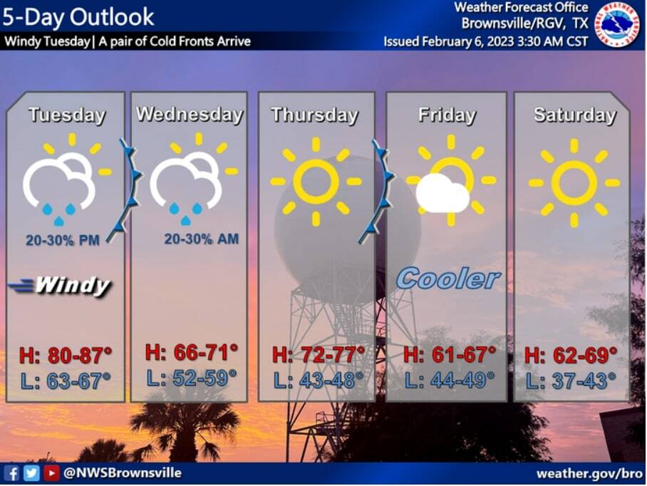
A couple of cold fronts will push through the Rio Grande Valley this week bringing cooler temperatures to the area.
And although it won’t be as cold as last week, there will be some cooler days ahead.
The high temperatures are expected to be in the 80s until Tuesday.
Then, they will drop somewhere between 14 to 16 degrees Wednesday, with temperatures in the mid to upper 60s, the National Weather Service in Brownsville/Rio Grande Valley reports.
According to the NWS, an active mid-level flow will bring the pair of cold fronts to the Valley.
The first cold front is expected to arrive Tuesday night into Wednesday morning. Showers and isolated thunderstorms are expected along and ahead of this front Tuesday night.
“The Storm Prediction Center (SPC) continues to indicate that Deep South Texas remains within a general thunderstorm risk with a marginal risk of severe thunderstorms along the Texas Coastal Bend and SE coast, north of the CWA (County Warning Area),” the NWS reports.
The highs on Wednesday will be generally in the 60s with clearing skies late in the day. Mostly clear skies and light winds should allow temperatures to fall into the 40s Wednesday night.
The second cold front is expected to move through the area Thursday night into Friday morning. This cold front appears to be strong and should cool the Valley “off quite a bit for the weekend,” according to the NWS.
The high temperatures on Friday are expected to be in the low to mid 60s. The low temperatures Friday and Saturday night look quite cool, with widespread upper 30s to lower 40s.
The highs on Saturday are expected to be in the 60s with slightly warmer temperatures, then in the low to mid 70s on Sunday.


