

These spring and summer-like temperatures the Rio Grande Valley has been experiencing over the past couple of weeks were expected to change a little with the passage of a cold front late Tuesday afternoon.
The front will bring cooler temperatures to the Valley with the daytime highs in the 60s and the overnight lows in the 40s and 50s, the National Weather Service in Brownsville/Rio Grande Valley reports.
“Thanks to the cold front pushing through, our low temperatures for tonight (Tuesday) will be much colder in the 40s for most of Deep South Texas, though a few places may be close to the low 50s along the coast. Wednesday high temperatures get into the upper 60s for most of the region,” the NWS reports in its outlook.
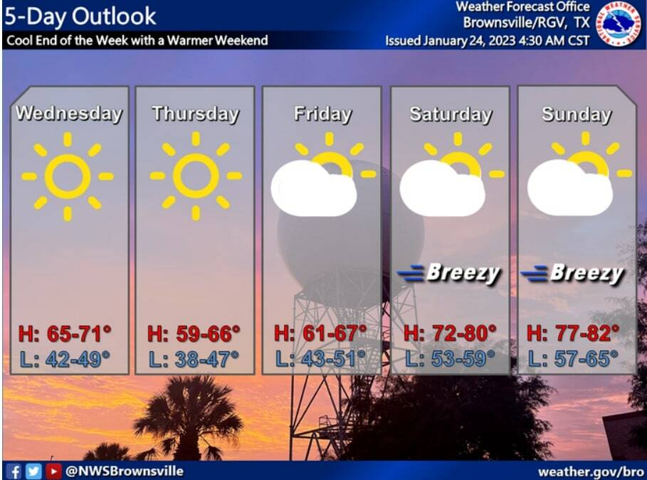
Thursday and Friday’s high will be in the mid-60s, while the overnight lows will be the mid-50s to near 60 degrees.
The temperatures will warm up over the weekend with the highs in the 70s.
Prior to the cold front’s arrival, many warnings were issued throughout the Valley, including high wind warnings, wind advisories, red flag warnings and fire danger statements.
Outdoor burnings were discouraged because the NWS stated that any fires that develop would spread quickly due to the strong winds.
In Brownsville, about 3,000 Brownsville Public Utilities Board customers experienced power outages early Tuesday afternoon because of the strong winds, BPUB reported.
The next chance of rain returns Saturday into Monday, mainly offshore or along the coast, with low pressure, abundant moisture, and potentially a frontal boundary in the area, the NWS reports.
And although the start of next week will be a warm one with highs in the 70s, there’s a chance that another cool front will pass through later next week, dropping temperatures into the 60s next Thursday, according to weather.com.


