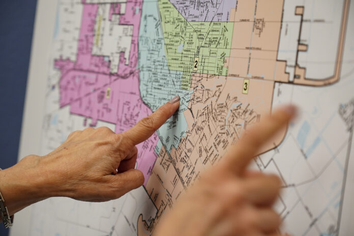
HARLINGEN — City leaders are questioning whether the redrawing of Harlingen’s five single-member districts’ lines could change the balance of power on the City Commission.
The redrawing of the boundaries stands to change some of the districts’ constituency, leading new voter bases to reshape the commission’s makeup, City Commissioner Frank Puente said Monday.
However, Mayor Chris Boswell downplayed the role the new district boundaries will play on the commission’s makeup.
Based on demographics such as income level, the new map which Commissioner Rene Perez designed shifts some of the city’s growing population across district lines.
“It could potentially change the outcome of power,” Puente said, adding three proposed maps could have also shifted the commission’s balance of power.
Overall make up diversified
In District 2, the new boundaries move an area including about 3,000 registered voters, many living in an upscale neighborhood along Austin Street, into District 3, which includes Treasure Hills, Boswell said, pointing to Precinct 32 and 35 registered voter numbers.
On Monday, Boswell questioned whether the removal of about 3,000 registered voters would impact the district’s overall makeup.
“I don’t see the perceived advantage of taking away the right to vote of so many people in an election,” he said, referring to residents moving from District 2 to District 3 who won’t be able to vote for their commissioner in May because District 3 elected its representative last year.
Boswell also questioned the overall makeup of the areas along Austin Street.
“There’s a notion that all the people moved from District 3 to District 2 are affluent, upscale voters,” he said. “There are a lot of people from different working-class backgrounds and different socio-economic backgrounds.”
Changing constituency
Meanwhile, Puente said the new map helps make District 2’s more uniform constituency offer better representation on the City Commission.
“It’s a more equal map,” he said. “I think it’s a little more diverse. You still have affluent people and you still have some working class.”
The map’s removal of much of the upscale area means former residents such as former City Commissioners Tudor Uhlhorn and Jay Meade won’t be able to run in district elections, Puente said.
“Now (Meade), Tudor or any of their buddies can’t run in that district,” he said.
Since a previous commission drew up the city’s original single-member district map in 2008, District 2’s upscale area spawned candidates who dominated some elections, Puente said.
“It was completely out of balance to their advantage,” he said, referring to candidates living in the upscale area. “They’re all lumped together — affluent and working-class. The working class were very little compared to the new map. If you have a district that’s almost all affluent people, who do you think will have the advantage?” he asked, noting those candidates’ money helps them outspend their working-class rivals.
More working-class voters
Meanwhile, Puente, who oversees District 2, said the new map draws population from working-class areas.
“It spreads more to the west-side so population is going to go up,” he said. “It’s going to La Placita, it’s going to Fair Park and to Loop 499 — the working-class.”
Puente said the new working-class population bloc will draw more prospective candidates to run in district elections.
“Now you add more people from the west side so we have more people who can run in my district,” he said.
Puente denies politics played role in map’s design
Puente strongly denied critics’ claim the new map is unconstitutional.
“A lot of people don’t understand it’s legal and normal,” he said, referring to the new map. “This is the byproduct of a growing, progressive city.”
Instead, he said the commission’s new majority designed the map to make the district’s composition more uniform.
“They’re trying to make it personal, talking politics,” he said. “They’re saying it’s politics — it’s not. It has nothing to do with keeping people out to give an advantage. They created this monster and when they lost control they cry about it.”
Meanwhile, Puente also denied he backed the new boundaries because he planned to seek election in the district after he runs for congressional District 37’s state representative seat.
“I don’t know why they think I’ve got a stake in this,” he said. “I had no input in this map. There was no stake in it for me.”
Background
The law called on commissioners to realign boundaries to try to balance the five districts’ population numbers.
Based on the new Census, San Antonio-based attorney Rolando Rios, whom the city contracted to help draw up the district map, first proposed shifting population blocs from fast-growing Districts 3 and 5 into Districts 1 and 4, where figures show slower growth during the decade in which the city’s total population climbed from 65,074 to 71,829.
Such a move wouldn’t stop residents from voting in the May election, he said.
However, Perez said he opposed Rios’ proposal to move the so-called U.S. Homes subdivision, which he described as a critical voting bloc, into District 4.
The city’s new Census figures showed the districts’ biggest population gains since a previous commission drew up the original map more than 13 years ago.
Census figures show District 5, running along the city’s west side, picked up the biggest population boost, pushing its total numbers to 17,733, according to Rios’ proposal.
During the last 10 years, growth also swept across District 3, which numbered 14,757 residents, and District 1, with 14,135 residents.
Meanwhile, growth remained stable across much of Districts 2 and 4.
In his proposal, Rios described each district’s “ideal” population as totaling 14,366 based on the new Census that set the city’s population at 71,829.
After voters adopted single-member district representation in 2008, Rios helped officials draw up the city’s original five-district map before helping a previous commission revise its boundaries following the 2010 Census.


