

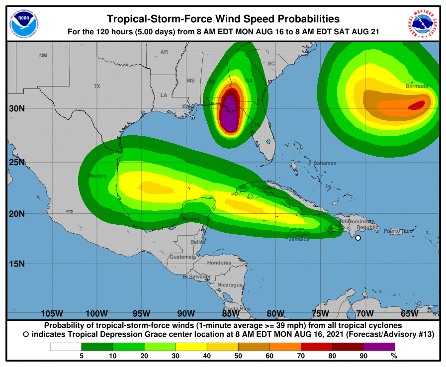
A tropical disturbance roiling the waters of the Caribbean is expected to strengthen and make a beeline toward northern Mexico, with a remote possibility of striking the Rio Grande Valley.
Tropical Disturbance Grace was sitting south of the island of Hispaniola on Monday, churning westward at 15 mph.
The storm is expected to strengthen and be named Tropical Storm Grace Tuesday, although computer models don’t see Grace packing enough punch to become a hurricane by the time it makes landfall this weekend.
“It looks like the track is going to remain very westerly through its history which will probably bring it into Mexico well to your south,” Dave Bowers, a senior meteorologist with AccuWeather, said Monday.
“Our window of movement here would still allow the possibility for it to be as far north as the Valley, but you’re right on the northern edge of what we could possibly see at this point,” he added.
The computer modeling for Grace is pretty consistent that it will lurch across the Caribbean on a westerly track, strike a glancing blow to the Yucatan Peninsula, then cross the Gulf of Mexico before making landfall Saturday somewhere to the north of Tampico, Mexico.
“It has a lot of warmer water to cross once it gets into the Gulf of Mexico,” Bowers said. “But it’s also going to be encountering some moderate shear which is why they don’t strengthen it to a hurricane.”
“But we’ve still got days to go here, and if that shear relaxes a little bit, it could ramp up,” he added. “But right now that seems less than 50-50.”
The National Weather Service reported Monday that U.S. Air Force Reserve and National Oceanic and Atmospheric Administration hurricane hunter planes were able to locate a center for the disturbance.
The planes did record several areas of potential tropical storm-force winds, which are anywhere between 39 and 73 miles per hour, but the observations were not confirmed by other methods and thus Grace remained a tropical disturbance Monday afternoon.
Hurricane forecasters have made dramatic improvements in their ability to predict a storm’s track but remain frustrated by their inability to be more precise when it comes to strengthening.
“It’s simply the complexity of all the parameters that you have to look at,” Bowers said. “The models only are as good as the information that gets pumped into them to start with.”
“Some of the basic ingredients would be sea surface temperatures, not only at the surface but even below the surface, the depth of the warm water, that could be fed into it,” he added. “And, of course, shear is a big issue, whether the storm is going to organize around a center without being inhibited or torn apart. And any other fronts that might come into play or troughs from the mainland would be an issue, and I’m sure there are other parameters to think about here as well.”
Something else to think about is we’re merely at the beginning of the most active phase of the 2021 Atlantic hurricane season, with the potential for tropical storms lasting until late October.
“This is a good shot across the bow,” Bowers said. “And it’s saying, ‘Hey, watch the tropics now.’”
Possible threats to the Valley:
- Elevated risk of rip currents throughout the weekend
- Elevated swells across the Gulf waters starting Friday
- Minor coastal run-up starting Friday and continuing into the weekend
- Rain Bands from Grace possibly producing locally heavy rainfall starting Friday and continuing into the weekend


